Le Bû-sur-Rouvres
Le Bû-sur-Rouvres (French pronunciation: [lə by syʁ ʁuvʁ] ⓘ, literally Le Bû on Rouvres) is a commune in the Calvados department in the Normandy region in northwestern France.
Le Bû-sur-Rouvres | |
|---|---|
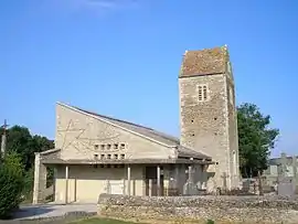 The church in Le Bû-sur-Rouvres | |
Location of Le Bû-sur-Rouvres | |
 Le Bû-sur-Rouvres  Le Bû-sur-Rouvres | |
| Coordinates: 49°02′03″N 0°10′44″W | |
| Country | France |
| Region | Normandy |
| Department | Calvados |
| Arrondissement | Caen |
| Canton | Le Hom |
| Intercommunality | Cingal-Suisse Normande |
| Government | |
| • Mayor (2020–2026) | Yves Ledent[1] |
| Area 1 | 2.83 km2 (1.09 sq mi) |
| Population | 113 |
| • Density | 40/km2 (100/sq mi) |
| Time zone | UTC+01:00 (CET) |
| • Summer (DST) | UTC+02:00 (CEST) |
| INSEE/Postal code | 14116 /14190 |
| Elevation | 71–94 m (233–308 ft) (avg. 80 m or 260 ft) |
| 1 French Land Register data, which excludes lakes, ponds, glaciers > 1 km2 (0.386 sq mi or 247 acres) and river estuaries. | |
Population
| Year | Pop. | ±% |
|---|---|---|
| 1962 | 93 | — |
| 1968 | 100 | +7.5% |
| 1975 | 90 | −10.0% |
| 1982 | 87 | −3.3% |
| 1990 | 85 | −2.3% |
| 1999 | 81 | −4.7% |
| 2008 | 106 | +30.9% |
See also
References
- "Répertoire national des élus: les maires" (in French). data.gouv.fr, Plateforme ouverte des données publiques françaises. 13 September 2022.
- "Populations légales 2020". The National Institute of Statistics and Economic Studies. 29 December 2022.
Wikimedia Commons has media related to Le Bû-sur-Rouvres.
This article is issued from Wikipedia. The text is licensed under Creative Commons - Attribution - Sharealike. Additional terms may apply for the media files.