Lalmonirhat Sadar Upazila
Lalmonirhat Sadar (Bengali: লালমনিরহাট সদর) is an upazila of Lalmonirhat District[1] in the Division of Rangpur, Bangladesh.
Lalmonirhat Sadar
লালমনিরহাট সদর | |
|---|---|
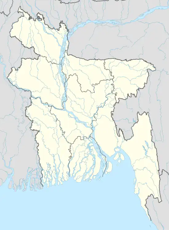 Lalmonirhat Sadar Location in Bangladesh | |
| Coordinates: 25°54.9′N 89°27′E | |
| Country | |
| Division | Rangpur Division |
| District | Lalmonirhat District |
| Area | |
| • Total | 259.54 km2 (100.21 sq mi) |
| Population (2011) | |
| • Total | 333,166 |
| • Density | 1,300/km2 (3,300/sq mi) |
| Time zone | UTC+6 (BST) |
| Website | Official Map of Lalmonirhat Sadar |
Geography
Lalmonirhat Sadar is located at 25.9153°N 89.4500°E. It has a total area of 259.54 km2. Teesta River flows inside this upazila.
Demographics
| Year | Pop. (000) | ±% |
|---|---|---|
| 1981 | 212 | — |
| 1991 | 261 | +23.1% |
| 2001 | 289 | +10.7% |
| 2011 | 333 | +15.2% |
| Source: Bangladesh Bureau of Statistics[2] | ||
According to the 2011 Bangladesh census, Lalmonirhat Sadar Upazila had 79,147 households and a population of 333,166, 18.1% of whom lived in urban areas. 10.5% of the population was under the age of 5. The literacy rate (age 7 and over) was 47.5%, compared to the national average of 51.8%.[3][4]
Administration
Lalmonirhat Sadar Upazila is divided into Lalmonirhat Municipality and nine union parishads: Barobari, Gokunda, Harati, Khuniagachh, Kulaghat, Mogolhat, Mohendranagar, Panchagram, and Rajpur. The union parishads are subdivided into 117 mauzas and 173 villages.[2]
Lalmonirhat Municipality is subdivided into 9 wards and 64 mahallas.[2]
Education
There are 19 colleges in the upazila. They include honors level Lalmonirhat Government College.[1][5]
See also
References
- Tanzimul Nayan (2012). "Lalmonirhat Sadar Upazila". In Sirajul Islam and Ahmed A. Jamal (ed.). Banglapedia: National Encyclopedia of Bangladesh (Second ed.). Asiatic Society of Bangladesh.
- "District Statistics 2011: Lalmonirhat" (PDF). Bangladesh Bureau of Statistics. Archived from the original (PDF) on 13 November 2014. Retrieved 14 July 2014.
- "Community Report: Lalmonirhat" (PDF). Population & Housing Census 2011. Bangladesh Bureau of Statistics. Retrieved 15 August 2018.
- "Population and Housing Census 2011: Bangladesh at a Glance" (PDF). Bangladesh Bureau of Statistics. Archived from the original (PDF) on 28 July 2014. Retrieved 21 July 2014.
- "List of Institutions". Ministry of Education. Retrieved July 15, 2014.
| Upazila/Thana: | ||
|---|---|---|
Capital: Rangpur | ||
| Dinajpur District |  | |
| Gaibandha District | ||
| Kurigram District | ||
| Lalmonirhat District | ||
| Nilphamari District | ||
| Panchagarh District | ||
| Rangpur District | ||
| Thakurgaon District | ||