Cosford Rural District
Cosford Rural District was a rural district in the county of West Suffolk, England. It was created in 1894 out of the earlier Cosford rural sanitary district, except for Hadleigh parish which was made a separate urban district. Only minor adjustments were made to its boundary in the reorganisation of 1935.[1] It was named after the historic hundred of Cosford, although the rural district covered a significantly larger area that included most of Cosford hundred (with the notable exception of Hadleigh) and part of the neighbouring hundred of Babergh.
| Cosford | |
|---|---|
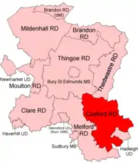 Location within West Suffolk, 1894 | |
| History | |
| • Created | 1894 |
| • Abolished | 1974 |
| • Succeeded by | Babergh |
| Status | Rural district |
Since 1 April 1974 it has formed part of the local government district of Babergh.
Parishes
Cosford RD contained the parishes of
- Aldham,
- Bildeston,
- Boxford,
- Brent Eleigh,
- Brettenham,
- Chelsworth,
- Cockfield,
- Edwardstone,
- Elmsett,
- Groton,
- Hadleigh Hamlet (abolished 1935),
- Hitcham,
- Kersey,
- Kettlebaston,
- Lavenham,
- Layham,
- Lindsey,
- Milden,
- Monks Eleigh,
- Nedging with Naughton (2 parishes before 1935),
- Polstead,
- Preston St Mary,
- Semer,
- Thorpe Morieux,
- Wattisham
- Whatfield.
Statistics
| Year | Area[2] | Population [3] |
Density (pop/ha) | |
|---|---|---|---|---|
| acres | ha | |||
| 1911 | 48,573 | 19,657 | 11,808 | 0.60 |
| 1921 | 10,392 | 0.53 | ||
| 1931 | 9,551 | 0.49 | ||
| 1951 | 48,530 | 19,640 | 9,536 | 0.49 |
| 1961 | 48,529 | 19,639 | 9,068 | 0.46 |
References
- "Cosford RD through time: Census tables with data for the Local Government District". A Vision of Britain through Time. GB Historical GIS / University of Portsmouth. Retrieved 8 July 2017.
- "Cosford RD through time: Population Statistics: Area (acres)". A Vision of Britain through Time. GB Historical GIS / University of Portsmouth. Retrieved 8 July 2017.
- "Cosford RD through time: Population Statistics: Total Population". A Vision of Britain through Time. GB Historical GIS / University of Portsmouth. Retrieved 8 July 2017.
| Pre-1974 |
| ||||||
|---|---|---|---|---|---|---|---|
| Post-1974 | |||||||
This article is issued from Wikipedia. The text is licensed under Creative Commons - Attribution - Sharealike. Additional terms may apply for the media files.