Suffolk Coastal
Suffolk Coastal was a local government district in Suffolk, England. Its council was based in Melton, having moved from neighbouring Woodbridge in 2017. Other towns include Felixstowe, Framlingham, Leiston, Aldeburgh, and Saxmundham.
Suffolk Coastal District | |
|---|---|
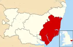 Suffolk Coastal shown within Suffolk and England | |
| Sovereign state | United Kingdom |
| Constituent country | England |
| Region | East of England |
| Non-metropolitan county | Suffolk |
| Status | Non-metropolitan district |
| Admin HQ | Melton |
| Incorporated | 1 April 1974 |
| Government | |
| • Type | Non-metropolitan district council |
| • Body | Suffolk Coastal District Council |
| • Leadership | Leader & Cabinet ( ) |
| • MPs | Therese Coffey Dan Poulter |
| Area | |
| • Total | 344.2 sq mi (891.5 km2) |
| Population (2017) | |
| • Total | 129,000 |
| • Density | 370/sq mi (140/km2) |
| • Ethnicity | 98.1% White |
| Time zone | UTC0 (GMT) |
| • Summer (DST) | UTC+1 (BST) |
| ONS code | 42UG (ONS) E07000205 (GSS) |
| OS grid reference | TM2756349450 |
| Website | www |
The district was formed on 1 April 1974, under the Local Government Act 1972, as a merger of the municipal borough of Aldeburgh, along with Felixstowe, Leiston-cum-Sizewell, Saxmundham and Woodbridge urban districts, and Blyth Rural District and Deben Rural District. The population of the district was 124,298 at the 2011 Census.[1]
Suffolk Coastal district was merged with Waveney district on 1 April 2019 to form the new East Suffolk district.[2]
Election results
There were new ward boundaries in 2003[3] and 2015.[4]
| Party | 2003[3] | 2007[5] | 2011[6] | 2015[4] | |
|---|---|---|---|---|---|
| Con | Conservative | 43 | 45 | 44 | 37 |
| LD | Liberal Democrats | 10 | 9 | 5 | 2 |
| Lab | Labour Party | 2 | 1 | 4 | 1 |
| Ind | Independent | 0 | 0 | 2 | 2 |
| Greens | Green Party | 0 | 0 | 0 | 0 |
| UKIP | UK Independence Party | 0 | 0 | 0 | 0 |
| FAC | Firefighters Against Cuts | 0 | n/a | n/a | n/a |
| Result | Largest party | Con | Con | Con | Con |
| Majority | 31 | 35 | 33 | 32 | |
| Total no. of seats | 55 | 55 | 55 | 42 |
Wards represented
Below is a list of wards with the number of councillors they returned in the relevant periods. There were 118 civil parishes and towns distributed amongst these wards.
| Ward | No. of Cllrs. 2003-2015[3] | Communities 2003-2015[7] | No. of Cllrs. 2015-2019[4] | Communities 2015–2019 |
|---|---|---|---|---|
| Aldeburgh | 2 | Aldeburgh Ward: Aldeburgh Town Buxlow Ward: Aldringham cum Thorpe, |
2 | |
| Deben | 0 | n/a | 1 | |
| Earl Soham | 1 | Earl Soham Ward: Brandeston; Earl Soham; Easton; Kettleburgh; Letheringham Hasketon Ward:, Charsfield Otley Ward: Cretingham, Hoo, Monewden |
0 | n/a |
| Farlingaye | 1 | Farlingaye ward: Farlingaye ward of Woodbridge Town Woodbridge Central ward: Central ward of Woodbridge Town (part) Woodbridge Seckford Ward: Seckford ward of Woodbridge Town (part) |
0 | n/a |
| Felixstowe East | 2 | Felixstowe East Ward: East ward of Felixstowe Town (part) Felixstowe North Ward: North ward of Felixstowe Town (part) Felixstowe South East Ward: South East ward of Felixstowe Town (part) |
2 | |
| Felixstowe North | 2 | Felixstowe Central Ward: Central ward of Felixstowe Town (part) Felixstowe North Ward: North ward of Felixstowe Town (part) Felixstowe South East Ward: South East ward of Felixstowe Town (part) |
2 | |
| Felixstowe South | 2 | Felixstowe Central Ward: Central ward of Felixstowe Town (part) Felixstowe South Ward: South ward of Felixstowe Town (part) Felixstowe West ward:West ward of Felixstowe Town (part) |
2 | |
| Felixstowe South East | 2 | Felixstowe Central Ward: Central ward of Felixstowe Town (part) East ward of Felixstowe Town (part) Felixstowe South Ward:South ward of Felixstowe Town (part) Felixstowe South East Ward: South East ward of Felixstowe Town (part) |
0 | n/a |
| Felixstowe West | 3 | Felixstowe Central Ward: Central ward of Felixstowe Town (part) Felixstowe West Ward: West ward of Felixstowe Town (part) |
2 | |
| Framlingham | 2 | Framlingham Ward Framlingham Town Dennington Ward: Dennington (part); Badingham Earl Soham ward: Saxtead (part) |
2 | Framlingham |
| Fynn Valley | 0 | n/a | 1 | |
| Grundisburgh | 1 | Bealings Ward: Great Bealings (part); Little Bealings; Grundisburgh & Witnesham Ward: Culpho (part); Grundisburgh; | 1 | |
| Hacheston | 1 | Dennington Ward: Bruisyard; Cransford; Rendham; Swefling Glemham Ward: Great Glemham; Hacheston; Little Glemham; Marlesford; Parham |
1 | |
| Hollesley with Eyke | 1 | Hollesley Ward: Boyton; Butley; Capel St Andrew; Hollesley; Wantisden Tunstall Ward: Chillesford; Ufford Ward: Eyke |
0 | n/a |
| Kesgrave East | 3 | Kesgrave Ward: Kesgrave East; Martlesham Ward: Martlesham West |
2 | |
| Kesgrave West | 2 | Kesgrave Ward: Kesgrave West; | 2 | |
| Kirton | 0 | n/a | 1 | |
| Kyson | 1 | Woodbridge Kyson Ward: Woodbridge Seckford Ward |
0 | n/a |
| Leiston | 3 | Buxlow Ward: Knodishall Leiston Ward: Leiston Town |
2 | |
| Martlesham | 2 | Martlesham Ward: Martlesham | 2 | |
| Melton | 0 | n/a | 2 | |
| Melton and Ufford | 2 | Melton Ward: Melton Ufford Ward: Ufford; Pettistree |
0 | n/a |
| Nacton | 2 | Kirton Ward: Hemley; Newbourne; Waldringfield Nacton Ward: Brightwell; Bucklesham; Foxhall; Levington; Nacton; Purdis Farm; Stratton Hall |
0 | n/a |
| Nacton and Purdis Farm | 0 | n/a | 1 | |
| Orford and Tunstall | 1 | Orford Ward: Gedgrave; Iken; Orford; and Sudbourne Tunstall ward: Blaxhall; Tunstall |
0 | n/a |
| Orford and Eyke | 0 | n/a | 1 | |
| Otley | 1 | Hasketon Ward: Boulge; Bredfield; Burgh; Dallinghoo; Debach; Hasketon (part) Otley Ward: Clopton; Otley |
0 | n/a |
| Peasenhall | 1 | Bramfield an Cratfield Ward: Cookley (part); Cookley; Cratfield; Heveningham; Huntingfield; Linstead Magna; Linstead Parva; Walpole; Yoxford Ward: Peasenhall (part); Sibton | 0 | n/a |
| Peasenhall and Yoxford | 0 | n/a | 1 | |
| Rendlesham | 1 | Tunstall Ward: Campsey Ash; Rendlesham | 1 | |
| Riverside | 1 | Martlesham Ward: Martlesham North ward Woodbridge Central Ward: Central ward of Woodbridge Town Woodbridge Riverside Ward: Riverside Ward of Woodbridge Town Woodbridge Seckford Ward: Seckford ward of Woodbridge Town |
0 | n/a |
| Rushmere St Andrew | 3 | Rushmere Ward: Rushmere St Andrew | 0 | n/a |
| Saxmundham | 2 | Kelsale Ward: Kelsale cum Carlton; Theberton Saxmundham Ward: Saxmundham Town |
2 | |
| Seckford | 1 | Woodbridge Seckford Ward: Seckford ward of Woodbridge Town (part) Woodbridge Central Ward: Central ward of Woodbridge Town (part) |
0 | n/a |
| Snape | 1 | Buxlow Ward: Friston (part) Snape Ward: Benhall; Farnham; Snape; Sternfield; Stratford St Andrew |
0 | n/a |
| Sutton | 1 | Alderton & Sutton Ward : Alderton, Bawdsey, Ramsholt, Shottisham, Sutton; Sutton Heath (from 2012)[8] Ufford Ward: Bromeswell |
0 | |
| Tower | 0 | n/a | 2 | |
| The Trimleys | 0 | n/a | 2 | |
| Trimleys with Kirton | 3 | Kirton Ward: Falkenham; Kirton Trimleys Ward: Trimley St Martin; Trimley St Mary |
0 | n/a |
| Walberswick and Wenhaston | 1 | Bramfield & Cratfield Ward: Bramfield (part); Thorington Walberswick Ward: Blythburgh; Walberswick; Wenhaston with Mells Hamlet |
0 | n/a |
| Wenhaston | 0 | n/a | 1 | |
| Wickham Market | 1 | Wickham Market | 1 | |
| Witnesham | 1 | Bealings Ward: Playford (part); Tuddenham St Martin; Westerfield Grundisburgh & Witnesham Ward: Swilland (part); Witnesham |
0 | n/a |
| Woodbridge | 0 | n/a | 3 | |
| Yoxford | 1 | Westleton ward: Darsham; Dunwich; Middleton; Westleton Yoxford Ward: Yoxford |
0 | n/a |
| Total | 55 | 42 |
Arms
|
References
- "District population 2011". Neighbourhood Statistics. Office for National Statistics. Retrieved 15 August 2016.
- Ministry of Housing, Communities and Local Government (24 May 2018). "The East Suffolk (Local Government Changes) Order 2018". legislation.gov.uk. Retrieved 28 May 2018.
- Teale, Andrew. "Local Election Results 2003 Suffolk Coastal". Local Elections Archive Project. Andrew Teale. Retrieved 21 March 2020.
- Teale, Andrew. "Local Election Results 2015 Suffolk Coastal". Local Elections Archive Project. Andrew Teale. Retrieved 21 March 2020.
- Teale, Andrew. "Local Election Results 2007 Suffolk Coastal". Local Elections Archive Project. Andrew Teale. Retrieved 21 March 2020.
- Teale, Andrew. "Local Election Results 2011 Suffolk Coastal". Local Elections Archive Project. Andrew Teale. Retrieved 21 March 2020.
- "Final recommendations on the future electoral arrangements for Suffolk Coastal" (PDF). Local Government Commission for England. 2001. Retrieved 22 March 2020.
- "Suffolk Coastal District Council (Reorganisation of Community Governance) (Sutton) Order 2012" (PDF). Local Government Boundary Commission for England. Retrieved 22 March 2020.
- "East of England Region". Civic Heraldry of England. Retrieved 9 March 2021.
External links
| Pre-1974 |
| ||||||
|---|---|---|---|---|---|---|---|
| Post-1974 | |||||||