Bretagne-d'Armagnac
Bretagne-d'Armagnac (French pronunciation: [bʁətaɲ daʁmaɲak], literally Bretagne of Armagnac; Occitan: Bretanha d'Armanhac) is a commune in the Gers department in southwestern France.
Bretagne-d'Armagnac | |
|---|---|
Location of Bretagne-d'Armagnac | |
 Bretagne-d'Armagnac  Bretagne-d'Armagnac | |
| Coordinates: 43°53′14″N 0°08′20″E | |
| Country | France |
| Region | Occitania |
| Department | Gers |
| Arrondissement | Condom |
| Canton | Armagnac-Ténarèze |
| Government | |
| • Mayor (2020–2026) | Gérard Gourgues[1] |
| Area 1 | 12.35 km2 (4.77 sq mi) |
| Population | 397 |
| • Density | 32/km2 (83/sq mi) |
| Time zone | UTC+01:00 (CET) |
| • Summer (DST) | UTC+02:00 (CEST) |
| INSEE/Postal code | 32064 /32800 |
| Elevation | 113–185 m (371–607 ft) (avg. 124 m or 407 ft) |
| 1 French Land Register data, which excludes lakes, ponds, glaciers > 1 km2 (0.386 sq mi or 247 acres) and river estuaries. | |
Geography
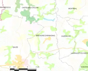
Bretagne-d'Armagnac and its surrounding communes
Population
| Year | Pop. | ±% |
|---|---|---|
| 1962 | 416 | — |
| 1968 | 388 | −6.7% |
| 1975 | 363 | −6.4% |
| 1982 | 392 | +8.0% |
| 1990 | 345 | −12.0% |
| 1999 | 345 | +0.0% |
| 2008 | 388 | +12.5% |
See also
References
- "Répertoire national des élus: les maires". data.gouv.fr, Plateforme ouverte des données publiques françaises (in French). 2 December 2020.
- "Populations légales 2020". The National Institute of Statistics and Economic Studies. 29 December 2022.
Wikimedia Commons has media related to Bretagne-d'Armagnac.
This article is issued from Wikipedia. The text is licensed under Creative Commons - Attribution - Sharealike. Additional terms may apply for the media files.