Brancourt-en-Laonnois
Brancourt-en-Laonnois is a commune in the department of Aisne in Hauts-de-France in northern France.
Brancourt-en-Laonnois | |
|---|---|
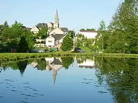 The lake and surroundings at Brancourt-en-Laonnois | |
.svg.png.webp) Coat of arms | |
Location of Brancourt-en-Laonnois | |
 Brancourt-en-Laonnois  Brancourt-en-Laonnois | |
| Coordinates: 49°30′55″N 3°25′10″E | |
| Country | France |
| Region | Hauts-de-France |
| Department | Aisne |
| Arrondissement | Laon |
| Canton | Laon-1 |
| Government | |
| • Mayor (2020–2026) | Marie-Laure Rouyer Thiebaut[1] |
| Area 1 | 6.56 km2 (2.53 sq mi) |
| Population | 726 |
| • Density | 110/km2 (290/sq mi) |
| Time zone | UTC+01:00 (CET) |
| • Summer (DST) | UTC+02:00 (CEST) |
| INSEE/Postal code | 02111 /02320 |
| Elevation | 63–179 m (207–587 ft) (avg. 80 m or 260 ft) |
| 1 French Land Register data, which excludes lakes, ponds, glaciers > 1 km2 (0.386 sq mi or 247 acres) and river estuaries. | |
Population
| Year | Pop. | ±% |
|---|---|---|
| 1962 | 345 | — |
| 1968 | 374 | +8.4% |
| 1975 | 415 | +11.0% |
| 1982 | 536 | +29.2% |
| 1990 | 710 | +32.5% |
| 1999 | 675 | −4.9% |
| 2008 | 641 | −5.0% |
See also
References
- "Répertoire national des élus: les maires". data.gouv.fr, Plateforme ouverte des données publiques françaises (in French). 9 August 2021.
- "Populations légales 2020". The National Institute of Statistics and Economic Studies. 29 December 2022.
Wikimedia Commons has media related to Brancourt-en-Laonnois.
This article is issued from Wikipedia. The text is licensed under Creative Commons - Attribution - Sharealike. Additional terms may apply for the media files.