Arataca
Arataca is a municipality in the state of Bahia in the North-East region of Brazil. Arataca covers 435.96 km2 (168.33 sq mi), and has a population of 10,961 with a population density of 27 inhabitants per square kilometer (70 inhabitants per square mile). It consists of two districts: Arataca, the municipal seat, and Itatingui. [2]
Arataca
Município de Arataca | |
|---|---|
 Seal | |
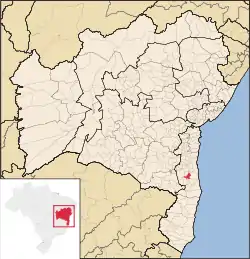 Location of Arataca in Bahia | |
 Arataca Location of Arataca in Brazil | |
| Coordinates: 15°15′46″S 39°24′50″W | |
| Country | |
| Region | Northeast |
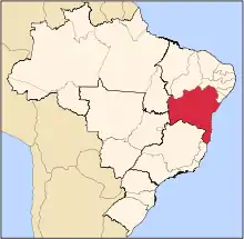
| State | |
| Founded | May 9, 1985 |
| Government | |
| • Mayor | Fernando Mansur (2013-2016) |
| Area | |
| • Total | 435.96 km2 (168.33 sq mi) |
| Population (2020 [1]) | |
| • Total | 10,961 |
| • Density | 25/km2 (65/sq mi) |
| Demonym | Arataquense |
| Time zone | UTC−3 (BRT) |
The municipality contains part of the 11,336 hectares (28,010 acres) Serra das Lontras National Park, created in 2010.[3]
See also
References
- IBGE 2020
- "Arataca" (in Portuguese). Brasília, Brazil: Instituto Brasileiro de Geografia e Estatstica. 2015. Retrieved 2015-08-24.
- Unidade de Conservação: Parque Nacional da Serra das Lontras (in Portuguese), MMA: Ministério do Meio Ambiente, retrieved 2016-06-09
This article is issued from Wikipedia. The text is licensed under Creative Commons - Attribution - Sharealike. Additional terms may apply for the media files.