Alamdanga Upazila
Alamdanga (Bengali: আলমডাঙ্গা) is an upazila of Chuadanga District in the Division of Khulna, Bangladesh. It covers an area of 380.38 square kilometres (146.87 sq mi).[1]
Alamdanga
আলমডাঙ্গা | |
|---|---|
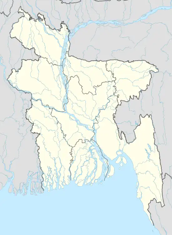 Alamdanga Location in Bangladesh | |
| Coordinates: 23°45.5′N 88°57′E | |
| Country | |
| Division | Khulna Division |
| District | Chuadanga District |
| Area | |
| • Total | 380.38 km2 (146.87 sq mi) |
| Population (2011) | |
| • Total | 345,922 |
| • Density | 910/km2 (2,400/sq mi) |
| Time zone | UTC+6 (BST) |
| Website | Official Map of Alamdanga |
Geography
Alamdanga is located at 23.7583°N 88.9500°E. It has 44,699 households and total area 360.4 km2.
Demographics
According to 2011 Bangladesh census, Alamdanga had a population of 345,922. Males constituted 49.99% of the population and females 50.01. Muslims formed 90.33% of the population, Hindus 2.61% Christians 7.93%, and others 0.045%. Alamdanga had a literacy rate of 45.67% for the population 7 years and above.[2]
As of the 2001 Bangladesh census, the population of the upazila was 308,917; males 158,951, females 149,966; Muslims 299,001, Hindus 8,919, Christians 11 and others 109.[3]
As of the 1991 Bangladesh census, Alamdanga had a population of 245,524. Males constituted 51.66% of the population, and females 48.34%. This upazila's population of individuals aged 18 and older was 127,055. Alamdanga had an average literacy rate of 23.2% (7+ years), and the national average of 32.4% literate.[4]
Arts and culture
Main source sources of income: Agriculture 41.76%, non-agriculture labourer 27.35%, industry 0.84%, business 12.54%, service 3.78%, construction 0.87%, religious service 0.17%, rent and remittance 0.43%, transport and communication 2.89% and others 6.01%.[1]
Madrasas and Technical Schools
- Madrasatut Taqwa (Alamdanga Madrasa)[5]
Public Library
- Swayambhar Public Library[6]
Administration
Alamdanga Thana was turned into an upazila in 1982.
Alamdanga Upazila is divided into Alamdanga Municipality and 15 union parishads: Ailhash, Belgachi, Baradi, Bhangbaria, Chitla, Dauki, Gagni, Hardi, Jamjami, Jehala, Kalidashpur, Khadimpur, Khashkorara, Kumari, and Nagdah. The union parishads are subdivided into 126 mauzas and 211 villages.[7][8]
Alamdanga Municipality is subdivided into 9 wards and 18 mahallas.[7]
Notable Person
- Mawlana Imdadul Haque, Islamic Scholar and Author [9]
References
- Md Faysal Kibria (2012), "Alamdanga Upazila", in Sirajul Islam and Ahmed A. Jamal (ed.), Banglapedia: National Encyclopedia of Bangladesh (Second ed.), Asiatic Society of Bangladesh
- "Bangladesh Population and Housing Census 2011: Zila Report – Chuadanga" (PDF). Table P01 : Household and Population by Sex and Residence, Table P05 : Population by Religion, Age group and Residence, Table P09 : Literacy of Population 7 Years & Above by Religion, Sex and Residence. Bangladesh Bureau of Statistics (BBS), Ministry of Planning, Government of the People’s Republic of Bangladesh. Retrieved 9 December 2018.
- Md Faysal Kibria (2012), "Alamdanga Upazila", in Sirajul Islam and Ahmed A. Jamal (ed.), Banglapedia: National Encyclopedia of Bangladesh (Second ed.), Asiatic Society of Bangladesh
- "Population Census Wing, BBS". Archived from the original on 2005-03-27. Retrieved November 10, 2006.
- |url=https://amar-school.com/list.php?search_type=thana&thana=ALAMDANGA&page=2 |title=Schools in Alamdanga |website=https://amar-school.com/list.php?search_type=thana&thana=ALAMDANGA&page=2 |publisher=Amar School
- নিউজ, সময়. "Somoy Tv News". Somoy News.
- "District Statistics 2011: Chuadanga" (PDF). Bangladesh Bureau of Statistics. Archived from the original (PDF) on 13 November 2014. Retrieved 14 July 2014.
- আলমডাঙ্গা উপজেলা [Unions]. Alamdanga Upazila (in Bengali).
- Shayekh Imdalul Haque Books - শাইখ ইমদাদুল হক এর বই. Rokomari (in Bengali). Dhaka.
| Upazilas | ||
|---|---|---|
| Constituencies | ||
| Inhabited areas | ||
| Transport | ||
| Education |
| |