YO postcode area
The YO postcode area, also known as the York postcode area,[1] is a group of 29 postcode districts in Yorkshire, England, within ten post towns. These cover most of Central and Eastern North Yorkshire (including York, Scarborough, Pickering, Selby, Thirsk, Malton, Filey and Whitby) and the northern part of the East Riding of Yorkshire (including Bridlington and Driffield). The rest of North Yorkshire is split between the TS, DL, LA, BD, HG, DN and WF postcode areas.
Template:Attached KML/YO postcode area
KML is from Wikidata
York | |
|---|---|
 YO | |
| Coordinates: 54.072°N 0.844°W | |
| Country | United Kingdom |
| Postcode area | YO |
| Postcode area name | York |
| Post towns | 10 |
| Postcode districts | 37 |
| Postcode sectors | 161 |
| Postcodes (live) | 18,600 |
| Postcodes (total) | 34,239 |
| Statistics as at May 2020[2] | |
Coverage
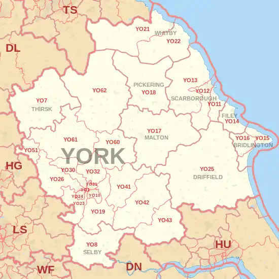
The approximate coverage of the postcode districts:
| Postcode district | Post town | Coverage | Local authority area(s) |
|---|---|---|---|
| YO1 | YORK | City Centre | City of York Council |
| YO7 | THIRSK | Dalton, Hambleton, Thirsk, Topcliffe | North Yorkshire Council |
| YO8 | SELBY | Barlby, Brayton, Bubwith, Cawood, Camblesforth, Drax, Selby, Thorpe Willoughby | North Yorkshire Council |
| YO10 | YORK | Fishergate, Fulford, Heslington, Osbaldwick, Tang Hall | City of York Council |
| YO11 | SCARBOROUGH | Cayton, Eastfield | North Yorkshire Council |
| YO12 | SCARBOROUGH | Seamer | North Yorkshire Council |
| YO13 | SCARBOROUGH | North Yorkshire Council | |
| YO14 | FILEY | North Yorkshire Council | |
| YO15 | BRIDLINGTON | Bridlington, Bempton, Buckton, Carnaby, Flamborough, Fraisthorpe, Sewerby, Wilsthorpe | East Riding of Yorkshire |
| YO16 | BRIDLINGTON | Bridlington, Bempton, Bessingby, Boynton, Buckton, Carnaby, Grindale, Sewerby | East Riding of Yorkshire |
| YO17 | MALTON | Norton | North Yorkshire Council |
| YO18 | PICKERING | Pickering, Thornton-le-Dale | North Yorkshire Council |
| YO19 | YORK | Dunnington, Escrick, Wheldrake, Murton, Riccall, Stillingfleet, Warthill | City of York Council, North Yorkshire Council |
| YO21 | WHITBY | Whitby, Westerdale | North Yorkshire Council |
| YO22 | WHITBY | Robin Hood's Bay | North Yorkshire Council |
| YO23 | YORK | South Bank, Bishopthorpe, Copmanthorpe, Rufforth | City of York Council, North Yorkshire Council |
| YO24 | YORK | Acomb, Dringhouses, Woodthorpe | City of York Council |
| YO25 | DRIFFIELD | Driffield | East Riding of Yorkshire |
| YO26 | YORK | Acomb, Leeman Road Area, Upper Poppleton, Nether Poppleton, Green Hammerton | City of York Council, North Yorkshire Council |
| YO30 | YORK | Bootham, Clifton, Skelton, Linton-on-Ouse | City of York Council, North Yorkshire Council |
| YO31 | YORK | Heworth, Huntington (South), The Groves, Layerthorpe | City of York Council |
| YO32 | YORK | Haxby, Huntington (North), Wigginton, New Earswick, Stockton-on-the-Forest, Strensall | City of York Council |
| YO41 | YORK | Elvington, Full Sutton, Stamford Bridge, Sutton upon Derwent, Wilberfoss | City of York Council, East Riding of Yorkshire |
| YO42 | YORK | Pocklington, Barmby Moor, Melbourne, Seaton Ross | East Riding of Yorkshire |
| YO43 | YORK | Market Weighton, Holme-on-Spalding-Moor | East Riding of Yorkshire |
| YO51 | YORK | Boroughbridge | North Yorkshire Council |
| YO60 | YORK | Sheriff Hutton | |
| YO61 | YORK | Easingwold | North Yorkshire Council |
| YO62 | YORK | Helmsley, Kirkbymoorside, Nawton | North Yorkshire Council |
| YO90 | YORK | Large offices in Rougier Street and Wellington Row in York |
Map
Template:Attached KML/YO postcode area
KML is from Wikidata
References
- Royal Mail, Address Management Guide, (2004)
- "ONS Postcode Directory Version Notes" (ZIP). National Statistics Postcode Products. Office for National Statistics. May 2020. Table 2. Retrieved 19 June 2020. Coordinates from mean of unit postcode points, "Code-Point Open". OS OpenData. Ordnance Survey. February 2012. Retrieved 21 April 2012.
External links
This article is issued from Wikipedia. The text is licensed under Creative Commons - Attribution - Sharealike. Additional terms may apply for the media files.