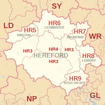
HR postcode area
The HR postcode area, also known as the Hereford postcode area,[2] is a group of nine postcode districts in England and Wales, which are subdivisions of six post towns. These cover most of Herefordshire, including Hereford, Bromyard, Kington, Ledbury, Leominster and Ross-on-Wye, while the HR2, HR3 and HR5 districts extend across the border to cover a small part of Powys.
Template:Attached KML/HR postcode area
KML is from Wikidata
Hereford | |
|---|---|
 HR | |
| Coordinates: 52.069°N 2.724°W | |
| Country | United Kingdom |
| Postcode area | HR |
| Postcode area name | Hereford |
| Post towns | 6 |
| Postcode districts | 9 |
| Postcode sectors | 33 |
| Postcodes (live) | 6,387 |
| Postcodes (total) | 7,899 |
| Statistics as at May 2020[1] | |
Coverage
The approximate coverage of the postcode districts:
| Postcode district | Post town | Coverage | Local authority area(s) |
|---|---|---|---|
| HR1 | HEREFORD | North of centre | Herefordshire Council |
| HR2 | HEREFORD | South of centre | Herefordshire Council, Powys |
| HR3 | HEREFORD | West of centre; Hay on Wye | Herefordshire Council, Powys |
| HR4 | HEREFORD | City centre | Herefordshire Council |
| HR5 | KINGTON | Herefordshire Council, Powys | |
| HR6 | LEOMINSTER | Herefordshire Council | |
| HR7 | BROMYARD | Herefordshire Council | |
| HR8 | LEDBURY | Ledbury, Bosbury | Herefordshire Council |
| HR9 | ROSS-ON-WYE | Herefordshire Council |
Map
Template:Attached KML/HR postcode area
KML is from Wikidata
References
- "ONS Postcode Directory Version Notes" (ZIP). National Statistics Postcode Products. Office for National Statistics. May 2020. Table 2. Retrieved 19 June 2020. Coordinates from mean of unit postcode points, "Code-Point Open". OS OpenData. Ordnance Survey. February 2012. Retrieved 21 April 2012.
- Royal Mail, Address Management Guide, (2004)
External links
This article is issued from Wikipedia. The text is licensed under Creative Commons - Attribution - Sharealike. Additional terms may apply for the media files.