Wandle Park tram stop
Wandle Park tram stop is a stop adjacent to Wandle Park in the London Borough of Croydon in the southern suburbs of London. It serves the residential area between central Croydon and Waddon.
Wandle Park | |
|---|---|
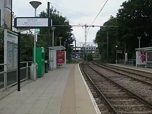 Wandle Park tram stop. Westbound platform looking west | |
| General information | |
| Location | Vicarage Road, Croydon United Kingdom |
| Operated by | Tramlink |
| Platforms | 2 |
| Construction | |
| Accessible | Yes |
| Other information | |
| Fare zone | London fare zones 3, 4, 5 and 6 |
| History | |
| Opened | 2000 |
| Passengers | |
| 2009–10 | 0.282 million total boardings and alightings[1] |
| 2010–11 | 0.319 million total boardings and alightings[2] |
The tram stop is located on a double track section of line, with platforms on either side of the track. Immediately to the east of the stop, the line reduces to single track and rises on a steep gradient in order to pass over the railway line on a bridge.
Until December 2019, it was a request stop in both directions. It is now a compulsory stop for trams towards Croydon, but a request stop for trams towards Wimbledon.
| Preceding station | Following station | |||
|---|---|---|---|---|
| Waddon Marsh towards Wimbledon |
Tramlink Wimbledon to Beckenham Junction |
Reeves Corner towards Beckenham Junction | ||
| Church Street One-way operation | ||||
| Tramlink Wimbledon to Elmers End |
Reeves Corner towards Elmers End | |||
| Church Street One-way operation | ||||
References
Wikimedia Commons has media related to Wandle Park tram stop.
- "Tram Stop Usage 2009-10 (FOI)" (XLS). Tramlink annual passenger performance 2009-2010. Transport for London. 18 August 2011. Retrieved 28 November 2012.
- "Tramlink numbers 2010-2011" (PDF). Tramlink annual passenger performance 2010-2011. Transport for London. 28 March 2012. Retrieved 28 November 2012.
| Tram stops |
| ||||||||
|---|---|---|---|---|---|---|---|---|---|
| Proposed developments |
| ||||||||
| Rolling stock | |||||||||
| Related topics | |||||||||
This article is issued from Wikipedia. The text is licensed under Creative Commons - Attribution - Sharealike. Additional terms may apply for the media files.