Wakemup, Minnesota
Wakemup is an unincorporated community in Beatty Township, Saint Louis County, Minnesota, United States.
Wakemup | |
|---|---|
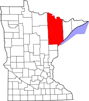
 Wakemup Location of the community of Wakemup within Beatty Township, Saint Louis County  Wakemup Wakemup (the United States) | |
| Coordinates: 47°55′27″N 92°38′43″W | |
| Country | United States |
| State | Minnesota |
| County | Saint Louis |
| Township | Beatty Township |
| Elevation | 1,371 ft (418 m) |
| Population | |
| • Total | 130 |
| Time zone | UTC-6 (Central (CST)) |
| • Summer (DST) | UTC-5 (CDT) |
| Area code | 218 |
| GNIS feature ID | 662731[1] |
The community is located six miles north of Cook, near Saint Louis County Road 24 (Vermilion Drive).
Wakemup is located within the Kabetogama State Forest.
References
- Official State of Minnesota Highway Map – 2011/2012 edition
This article is issued from Wikipedia. The text is licensed under Creative Commons - Attribution - Sharealike. Additional terms may apply for the media files.