Vialas
Vialas (French pronunciation: [vjalas]; Occitan: Vialars) is a commune in the Lozère department in southern France.[3]
Vialas | |
|---|---|
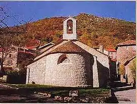 Protestant church in Vialas | |
 Coat of arms | |
Location of Vialas | |
 Vialas  Vialas | |
| Coordinates: 44°20′04″N 3°53′48″E | |
| Country | France |
| Region | Occitania |
| Department | Lozère |
| Arrondissement | Florac |
| Canton | Saint-Étienne-du-Valdonnez |
| Government | |
| • Mayor (2020–2026) | Michel Reydon[1] |
| Area 1 | 49.77 km2 (19.22 sq mi) |
| Population | 429 |
| • Density | 8.6/km2 (22/sq mi) |
| Time zone | UTC+01:00 (CET) |
| • Summer (DST) | UTC+02:00 (CEST) |
| INSEE/Postal code | 48194 /48220 |
| Elevation | 335–1,509 m (1,099–4,951 ft) (avg. 610 m or 2,000 ft) |
| 1 French Land Register data, which excludes lakes, ponds, glaciers > 1 km2 (0.386 sq mi or 247 acres) and river estuaries. | |
Population
|
| ||||||||||||||||||||||||||||||||||||||||||||||||||||||||||||||||||||||||||||||||||||||||||||||||||||||||||||||||||
| Source: EHESS[4] and INSEE[5] | |||||||||||||||||||||||||||||||||||||||||||||||||||||||||||||||||||||||||||||||||||||||||||||||||||||||||||||||||||
See also
References
- "Répertoire national des élus: les maires". data.gouv.fr, Plateforme ouverte des données publiques françaises (in French). 2 December 2020.
- "Populations légales 2020". The National Institute of Statistics and Economic Studies. 29 December 2022.
- INSEE commune file
- Des villages de Cassini aux communes d'aujourd'hui: Commune data sheet Vialas, EHESS (in French).
- Population en historique depuis 1968, INSEE
Wikimedia Commons has media related to Vialas.
This article is issued from Wikipedia. The text is licensed under Creative Commons - Attribution - Sharealike. Additional terms may apply for the media files.