Marchastel, Lozère
Marchastel (French pronunciation: [maʁʃastɛl]; Occitan: Marchastèl) is a commune in the Lozère department in southern France.[3]
Marchastel | |
|---|---|
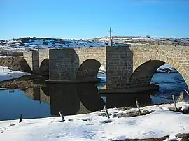 The Marchastel bridge, over the river Bès | |
Location of Marchastel | |
 Marchastel  Marchastel | |
| Coordinates: 44°39′07″N 3°06′27″E | |
| Country | France |
| Region | Occitania |
| Department | Lozère |
| Arrondissement | Mende |
| Canton | Peyre en Aubrac |
| Intercommunality | Hautes Terres de l'Aubrac |
| Government | |
| • Mayor (2020–2026) | Éric Malherbe[1] |
| Area 1 | 34.87 km2 (13.46 sq mi) |
| Population | 46 |
| • Density | 1.3/km2 (3.4/sq mi) |
| Time zone | UTC+01:00 (CET) |
| • Summer (DST) | UTC+02:00 (CEST) |
| INSEE/Postal code | 48091 /48260 |
| Elevation | 1,139–1,304 m (3,737–4,278 ft) (avg. 1,200 m or 3,900 ft) |
| 1 French Land Register data, which excludes lakes, ponds, glaciers > 1 km2 (0.386 sq mi or 247 acres) and river estuaries. | |
See also
References
- "Répertoire national des élus: les maires". data.gouv.fr, Plateforme ouverte des données publiques françaises (in French). 2 December 2020.
- "Populations légales 2020". The National Institute of Statistics and Economic Studies. 29 December 2022.
- INSEE commune file
Wikimedia Commons has media related to Marchastel, Lozère.
This article is issued from Wikipedia. The text is licensed under Creative Commons - Attribution - Sharealike. Additional terms may apply for the media files.