Valencia, Santa Fe County, New Mexico
Valencia is an unincorporated community and census-designated place (CDP) in Santa Fe County, New Mexico, United States. It was first listed as a CDP prior to the 2020 census.[3]
Valencia, New Mexico | |
|---|---|
 Valencia  Valencia | |
| Coordinates: 35°34′44″N 105°47′33″W | |
| Country | United States |
| State | New Mexico |
| County | Santa Fe |
| Area | |
| • Total | 1.55 sq mi (4.01 km2) |
| • Land | 1.55 sq mi (4.01 km2) |
| • Water | 0.00 sq mi (0.00 km2) |
| Elevation | 7,370 ft (2,250 m) |
| Population | |
| • Total | 115 |
| • Density | 74.19/sq mi (28.65/km2) |
| Time zone | UTC-7 (Mountain (MST)) |
| • Summer (DST) | UTC-6 (MDT) |
| ZIP Code | |
| Area code | 505 |
| FIPS code | 35-81775 |
| GNIS feature ID | 2812759[3] |
The CDP is in eastern Santa Fe County, at the southern end of the Sangre de Cristo Mountains, and is bordered to the east by Glorieta. Interstate 25 passes through Valencia, with access from Exit 297. I-25 leads northwest (southbound) 17 miles (27 km) to Santa Fe and east (northbound) 49 miles (79 km) to Las Vegas, New Mexico. The highway crosses Glorieta Pass at the eastern border of the CDP.
Education
It is within Santa Fe Public Schools.[5]
It is zoned to El Dorado Community School (K-8) in El Dorado. Its high school is Santa Fe High School.[6]
References
- "ArcGIS REST Services Directory". United States Census Bureau. Retrieved October 12, 2022.
- "Census Population API". United States Census Bureau. Retrieved October 12, 2022.
- "Valencia Census Designated Place". Geographic Names Information System. United States Geological Survey, United States Department of the Interior.
- "Census of Population and Housing". Census.gov. Retrieved June 4, 2016.
- "2020 CENSUS - SCHOOL DISTRICT REFERENCE MAP: Santa Fe County, NM" (PDF). U.S. Census Bureau. Retrieved July 20, 2021.
- "School Zone Maps". Santa Fe Public Schools. Retrieved July 22, 2021.
Municipalities and communities of Santa Fe County, New Mexico, United States | ||
|---|---|---|
| Cities | 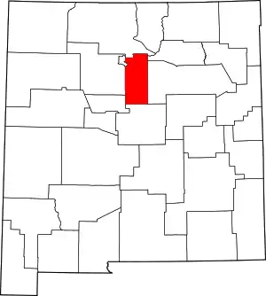 Map of New Mexico highlighting Santa Fe County | |
| Town | ||
| CDPs |
| |
| Other communities | ||
| Ghost town | ||
| Indian reservation | ||
| Footnotes | ‡This populated place also has portions in an adjacent county or counties | |
This article is issued from Wikipedia. The text is licensed under Creative Commons - Attribution - Sharealike. Additional terms may apply for the media files.