The President (mountain)
The President is a mountain peak on The President/Vice-President Massif of the President Range, in eastern British Columbia. It is just north of Emerald Lake in Yoho National Park, near the Alpine Club of Canada's Stanley Mitchell hut.
| The President | |
|---|---|
_from_Isolated_col_(skiout).jpg.webp) | |
| Highest point | |
| Elevation | 3,123 m (10,246 ft)[1] |
| Prominence | 658 m (2,159 ft)[1] (above Kiwetinok Pass) |
| Coordinates | 51°30′03″N 116°33′43″W[2] |
| Geography | |
 The President | |
| District | Kootenay Land District |
| Parent range | President Range Canadian Rockies |
| Topo map | NTS 82N10 Blaeberry River |
| Climbing | |
| First ascent | 1901 by James Outram, Christian Kaufmann and Joseph Pollinger[3] |
| Easiest route | scramble |
History
The President was named Shaugnessy in 1904 by Edward Whymper after Thomas Shaugnessy, the president of the Canadian Pacific Railway.[2] In 1907, the mountain was renamed by the Alpine Club of Canada, after it was discovered that the name had already been used on a mountain in the Selkirks.[1]
Climate
Based on the Köppen climate classification, The President is located in a subarctic climate with cold, snowy winters, and mild summers.[4] Temperatures can drop below −20 C with wind chill factors below −30 C.
References
- "The President". Bivouac.com. bivouac.com. Retrieved 2013-04-28.
- "The President". BC Geographical Names. Retrieved 2013-04-28.
- "The President". cdnrockiesdatabases.ca. Retrieved 2019-12-16.
- Peel, M. C.; Finlayson, B. L. & McMahon, T. A. (2007). "Updated world map of the Köppen−Geiger climate classification". Hydrol. Earth Syst. Sci. 11: 1633–1644. ISSN 1027-5606.
External links
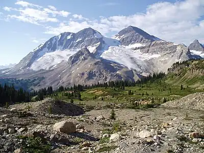
Left to right, The Vice President, President Glacier, and The President
This article is issued from Wikipedia. The text is licensed under Creative Commons - Attribution - Sharealike. Additional terms may apply for the media files.