Rainbow Range (Rocky Mountains)
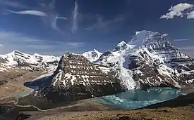
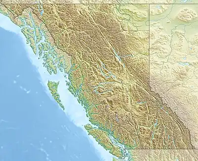
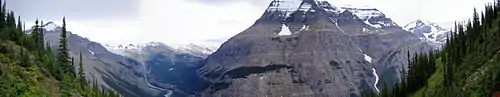
The Rainbow Range is a small subrange of the Park Ranges subdivisions of the Northern Continental Ranges of the Rocky Mountains on the border between Alberta and British Columbia in Mount Robson Provincial Park.
| Rainbow Range | |
|---|---|
 | |
| Highest point | |
| Peak | Mount Robson |
| Elevation | 3,954 m (12,972 ft)[1] |
| Prominence | 2,829 m (9,281 ft)[2] |
| Listing | |
| Coordinates | 53°06′38″N 119°09′23″W[3] |
| Dimensions | |
| Area | 497 km2 (192 sq mi)[4] |
| Geography | |
  | |
| Country | Canada |
| Provinces | British Columbia and Alberta |
| Range coordinates | 53°03′N 119°03′W[5] |
| Parent range | Canadian Rockies |
| Topo map | NTS 83D15 Lucerne[5] |
Its highest summit, and the highest in the Canadian Rockies, is Mount Robson 3,954 m (12,972 ft), followed by nearby Resplendent Mountain 3,425 m (11,237 ft).
Mountains and peaks
| Name | Elevation | Prominence | FA | Easiest route | Coordinates | ||
|---|---|---|---|---|---|---|---|
| m | ft | m | ft | ||||
| Mount Robson | 12,972
style="text-align:right;" data-sort-value="7003282900000000000"|2,829 |
9,281 | 1913 | South face (UIAA IV) | 53°6'38"N, 119°9'23"W | ||
| Resplendent Mountain | 11,237
style="text-align:right;" data-sort-value="7002483000000000000"|483 |
1,585 | 1911 | North face (UIAA II) | 53°5'15"N, 119°5'53"W | ||
| The Helmet | 11,220
style="text-align:right;" data-sort-value="7002128000000000000"|128 |
420 | 1928 | 53°6'54"N, 119°8'30"W | |||
| Lynx Mountain | 10,472
style="text-align:right;" data-sort-value="7002425000000000000"|425 |
1,394 | 1913 | 53°7'35"N, 119°2'53"W | |||
| Tatei Ridge | 9,551
style="text-align:right;" data-sort-value="7001800000000000000"|80 |
260 | Tatei is the Stoney Indian word for "wind" | 53°9'39"N, 119°4'46"W | |||
| Mount Waffl | 9,480
style="text-align:right;" data-sort-value="7002163000000000000"|163 |
535 | |||||
| Mount Kain | 9,450
style="text-align:right;" data-sort-value="7002239000000000000"|239 |
784 | 1934 | Basic rock climb | 53°3'8"N, 119°2'25"W | ||
| Titkana Peak | 9,199
style="text-align:right;" data-sort-value="7002397000000000000"|397 |
1,302 | 1908 | 53°9'18"N, 119°3'54"W | |||
| Rearguard Mountain | 9,003
style="text-align:right;" data-sort-value="7002454000000000000"|454 |
1,490 | 1913 | Glacier travel, scramble | 53°8'38"N, 119°7'35"W | ||
| Razor Peak | 8,750
style="text-align:right;" data-sort-value="7002656000000000000"|656 |
2,152 | |||||
| Extinguisher Tower | 7,851
style="text-align:right;" data-sort-value="7001480000000000000"|48 |
157 | 53°7'10"N, 119°5'44"W | ||||
| Campion Mountain | 7,011
style="text-align:right;" data-sort-value="7001750000000000000"|75 |
246 | |||||
References
- "Mount Robson Provincial Park". BC Parks. Government of British Columbia. Retrieved 2019-08-19.
- "Mount Robson". Bivouac.com. Retrieved 2023-07-15.
- "Mount Robson". Geographical Names Data Base. Natural Resources Canada. Retrieved 2019-08-19.
- "Rainbow Range". Peakbagger.com. Retrieved 2012-05-19.
- "Rainbow Range". BC Geographical Names. Retrieved 2012-05-19.
External links
- Bivouac - Rainbow Range
This article is issued from Wikipedia. The text is licensed under Creative Commons - Attribution - Sharealike. Additional terms may apply for the media files.