Ball Range
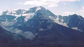
The Ball Range is a mountain range on the Continental Divide between Vermilion Pass and Red Earth Pass in Kootenay National Park, Canada.[5] The range is named after John Ball,[6] a politician who helped secure funding for the Palliser expedition.
| Ball Range | |
|---|---|
 | |
| Highest point | |
| Peak | Mount Ball |
| Elevation | 3,311 m (10,863 ft)[1] |
| Listing | |
| Coordinates | 51°09′23″N 116°00′23″W[2] |
| Dimensions | |
| Length | 26 km (16 mi) W-E[3] |
| Width | 35 km (22 mi) N-S[3] |
| Geography | |
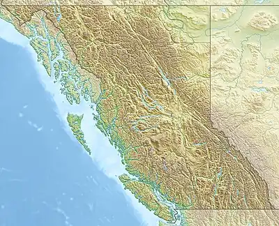 | |
| Country | Canada |
| Province | British Columbia |
| Range coordinates | 51°09′02″N 115°59′21″W[4] |
| Parent range | Canadian Rockies |
| Topo map | NTS 104O6 Tahoots Creek |
It extends over 465 km2 (180 sq mi), and measures 35 km (22 mi) from North to South and 26 km (16 mi) from East to West.[3]
Peaks
This range includes the following mountains and peaks:
| Mountain/Peak | Elevation (m/ft) | |
|---|---|---|
| Mount Ball | 3,311 | 10,863 |
| Stanley Peak | 3,155 | 10,351 |
| Beatrice Peak | 3,125 | 10,253 |
| Storm Mountain | 3,158 | 10,361 |
| Isabelle Peak | 2,926 | 9,600 |
| Haiduk Peak | 2,920 | 9,580 |
| Scarab Peak | 2,918 | 9,573 |
| The Monarch | 2,895 | 9,498 |
| Mount Shanks | 2,838 | 9,311 |
| Copper Mountain | 2,795 | 9,170 |
References
- Kane, Alan (1999). "Mount Ball". Scrambles in the Canadian Rockies. Calgary: Rocky Mountain Books. pp. 216–217. ISBN 0-921102-67-4.
- "Mount Ball". Bivouac.com. Retrieved 2019-06-11.
- "Ball Range". Peakbagger.com. Retrieved 2019-06-11.
- "Ball Range". Geographical Names Data Base. Natural Resources Canada. Retrieved 2019-06-11.
- "Ball Range". cdnrockiesdatabases.ca. Retrieved 2019-06-11.
- "Ball Range". BC Geographical Names. Retrieved 2019-06-11.
This article is issued from Wikipedia. The text is licensed under Creative Commons - Attribution - Sharealike. Additional terms may apply for the media files.