Tersoal
Tersoal (Dutch: Terzool) is a village in Súdwest-Fryslân municipality in the province of Friesland, the Netherlands. It had a population of around 355 in January 2017.[3]
Terzool
Tersoal | |
|---|---|
Village | |
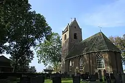 Tersoal Church | |
 Flag  Coat of arms | |
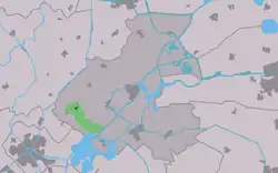 Location in the former Boarnsterhim municipality | |
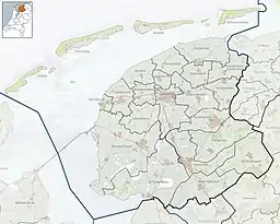 Terzool Location in the Netherlands  Terzool Terzool (Netherlands) | |
| Coordinates: 53°4′29″N 5°44′14″E | |
| Country | |
| Province | |
| Municipality | |
| Area | |
| • Total | 4.63 km2 (1.79 sq mi) |
| Elevation | 0.0 m (0.0 ft) |
| Population (2021)[1] | |
| • Total | 340 |
| • Density | 73/km2 (190/sq mi) |
| Postal code | 9014[1] |
| Dialing code | 0515 |
History
The village was first mentioned in 1335 as "in Zole", and means muddy stream.[4] Tersoal is a terp (artificial living hill) village to the south of the former Middelzee.[5] It used to be an isolated village which could only be accessed from the water.[6]
The Dutch Reformed church was built in 1838 as a replacement of the medieval church.[5] The tower dates from the 14th century.[6]
Tersoal was home to 235 people in 1840.[6] In 1866, a road was built and Tersoal developed in a road village.[5] Before 2011, the village was part of the Boarnsterhim municipality and before 1984 it belonged to Rauwerdhem municipality.[6]
Gallery
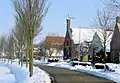 Tersoal in winter
References
- "Kerncijfers wijken en buurten 2021". Central Bureau of Statistics. Retrieved 6 April 2022.
- "Postcodetool for 9014BG". Actueel Hoogtebestand Nederland (in Dutch). Het Waterschapshuis. Retrieved 6 April 2022.
- Kerncijfers wijken en buurten 2017 - CBS Statline
- "Tersoal - (geografische naam)". Etymologiebank (in Dutch). Retrieved 6 April 2022.
- "Tersoal". Friesland wonderland (in Dutch). Retrieved 6 April 2022.
- "Tersoal". Plaatsengids (in Dutch). Retrieved 6 April 2022.