Sevrier
Sevrier (French pronunciation: [səvʁije]; before 2017: Sévrier; Arpitan: Sevrî)[3] is a commune in the Haute-Savoie department in the Auvergne-Rhône-Alpes region in south-eastern France.
Sevrier | |
|---|---|
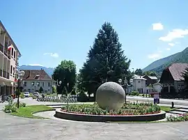 The Town Hall Square in Sevrier | |
 Coat of arms | |
Location of Sevrier | |
 Sevrier  Sevrier | |
| Coordinates: 45°51′55″N 6°08′26″E | |
| Country | France |
| Region | Auvergne-Rhône-Alpes |
| Department | Haute-Savoie |
| Arrondissement | Annecy |
| Canton | Annecy-2 |
| Intercommunality | CA Grand Annecy |
| Government | |
| • Mayor (2020–2026) | Bruno Lyonnaz[1] |
| Area 1 | 12.65 km2 (4.88 sq mi) |
| Population | 4,151 |
| • Density | 330/km2 (850/sq mi) |
| Time zone | UTC+01:00 (CET) |
| • Summer (DST) | UTC+02:00 (CEST) |
| INSEE/Postal code | 74267 /74320 |
| Elevation | 440–1,287 m (1,444–4,222 ft) (avg. 456 m or 1,496 ft) |
| 1 French Land Register data, which excludes lakes, ponds, glaciers > 1 km2 (0.386 sq mi or 247 acres) and river estuaries. | |
It is located on the north-western banks of Lake Annecy. It is essentially a residential suburb of Annecy.
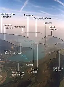
Geographical features around Lake Annecy
World Heritage Site
It is home to one or more prehistoric pile-dwelling (or stilt house) settlements that are part of the Prehistoric Pile dwellings around the Alps UNESCO World Heritage Site.[4]
References
- "Répertoire national des élus: les maires" (in French). data.gouv.fr, Plateforme ouverte des données publiques françaises. 13 September 2022.
- "Populations légales 2020". The National Institute of Statistics and Economic Studies. 29 December 2022.
- Décret n° 2017-149 7 February 2017 (in French)
- UNESCO World Heritage Site - Prehistoric Pile dwellings around the Alps
Wikimedia Commons has media related to Sevrier.
External links
This article is issued from Wikipedia. The text is licensed under Creative Commons - Attribution - Sharealike. Additional terms may apply for the media files.