Savojbolagh County
Savojbolagh County (Persian: شهرستان ساوجبلاغ) is in Alborz province, Iran. Its capital is the city of Hashtgerd.
Savojbolagh County
Persian: شهرستان ساوجبلاغ | |
|---|---|
County | |
 | |
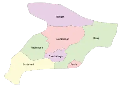 Location of Savojbolagh County in Alborz province (center, pink) | |
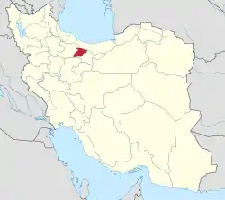 Location of Alborz province in Iran | |
| Coordinates: 35°58′N 50°49′E[1] | |
| Country | Iran |
| Province | Alborz |
| Capital | Hashtgerd |
| Districts | Central, Chendar |
| Population (2016)[2] | |
| • Total | 259,973 |
| Time zone | UTC+3:30 (IRST) |
At the 2006 census, when it was a county in Tehran province, its population was 215,086 in 57,497 households.[3] At the 2016 census, the county's population was 259,973 in 80,953 households, by which time the county had joined the recently established Alborz province, and Taleqan District had been separated from the county to form Taleqan County.[2] After the census, Chaharbagh District was separated from the county to become Chaharbagh County.[4]
Administrative divisions
The population history and structural changes of Savojbolagh County's administrative divisions over two censuses are shown in the following table. The latest census shows three districts, six rural districts, and five cities.[2]
| Administrative Divisions | 2006[3] | 2016[2] | |
|---|---|---|---|
| Central District | 106,879 | 153,675 | |
| Hiv Rural District | 14,352 | 15,164 | |
| Saidabad Rural District | 31,576 | 26,979 | |
| Golsar (city) | 13,745 | ||
| Hashtgerd (city) | 45,332 | 55,640 | |
| Shahr-e Jadid-e Mehestan (city) | 15,619 | 42,147 | |
| Chaharbagh District1 | 61,135 | 77,409 | |
| Chahardangeh Rural District | 38,598 | 5,233 | |
| Ramjin Rural District | 16,960 | 23,348 | |
| Chaharbagh (city) | 5,577 | 48,828 | |
| Chendar District | 21,291 | 28,841 | |
| Baraghan Rural District | 1,424 | 3,949 | |
| Chendar Rural District | 12,110 | 13,952 | |
| Kuhsar (city) | 7,757 | 10,940 | |
| Taleqan District2 | 25,781 | ||
| Bala Taleqan Rural District | 6,609 | ||
| Miyan Taleqan Rural District | 9,873 | ||
| Pain Taleqan Rural District | 6,018 | ||
| Taleqan (city) | 3,281 | ||
| Total | 215,086 | 259,973 | |
| 1Became a part of Chaharbagh County 2Became a part of Taleqan County | |||
History
The name Sāvojbolāgh is derived from Turkish and means "cold springs".[5] The 14th-century author Hamdallah Mustawfi described it as having "a fine climate"; most of its water was drawn from qanats, and it produced a lot of fruit and grain.[6] He wrote that the district had previously been attached to Ray for fiscal purposes under the Seljuk Empire, but under Mongol rule it had been detached.[6] Its inhabitants, he wrote, were nomads who were "indifferent to religious matters".[6] The main villages were Sonqorabad, Najmabad, and Kharav.[6] The district's tax revenues he listed as 12,000 dinars.[6]
References
- OpenStreetMap contributors (26 March 2023). "Savojbolagh County" (Map). OpenStreetMap. Retrieved 26 March 2023.
- "Census of the Islamic Republic of Iran, 1395 (2016)". AMAR (in Persian). The Statistical Center of Iran. p. 30. Archived from the original (Excel) on 28 January 2020. Retrieved 19 December 2022.
- "Census of the Islamic Republic of Iran, 1385 (2006)". AMAR (in Persian). The Statistical Center of Iran. p. 23. Archived from the original (Excel) on 20 September 2011. Retrieved 25 September 2022.
- "Letter of approval regarding country divisions in Savojbolagh County, Alborz province". Research Center Majlis (in Persian). Archived from the original on 24 June 2021. Retrieved 13 February 2021.
- Le Strange, Guy (1905). The Lands of the Eastern Caliphate: Mesopotamia, Persia, and Central Asia, from the Moslem Conquest to the Time of Timur. New York: Barnes & Noble, Inc. p. 218.
- Hamdallah Mustawfi (1919). Le Strange, Guy (ed.). The Geographical Part of the Nuzhat-al-Qulub. p. 69. Retrieved 10 October 2022.
| Capital city |  | ||||||||||||
|---|---|---|---|---|---|---|---|---|---|---|---|---|---|
| Counties and cities |
| ||||||||||||
| Sights |
| ||||||||||||
| Populated places | |||||||||||||
| Capital | |||||||||||||||||||||||||||||||
|---|---|---|---|---|---|---|---|---|---|---|---|---|---|---|---|---|---|---|---|---|---|---|---|---|---|---|---|---|---|---|---|
| Districts |
| ||||||||||||||||||||||||||||||