Rangárþing eystra
Rangárþing eystra (Icelandic pronunciation: [ˈrauŋkˌaurˌθiŋk ˌeistra] ⓘ) is a municipality located in southern Iceland in the Southern Region, between Eystri Rangá in the west and Jökulsá á Sólheimasandi in the east. The largest settlements are Skógar and Hvolsvöllur.
Rangárþing eystra | |
|---|---|
 Coat of arms | |
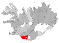 Location of Rangárþing eystra | |
| Country | Iceland |
| Region | Southern Region |
| Constituency | South Constituency |
| Government | |
| • Manager | Ísólfur Gylfi Pálmason |
| Area | |
| • Total | 1,841 km2 (711 sq mi) |
| Population | |
| • Total | 1,708 |
| • Density | 0.93/km2 (2.4/sq mi) |
| Postal code(s) | 860, 861 |
| Municipal number | 8613 |
| Website | hvolsvollur |
References
This article is issued from Wikipedia. The text is licensed under Creative Commons - Attribution - Sharealike. Additional terms may apply for the media files.