Quebec Route 358
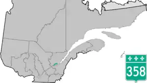
Route 358 is a provincial highway located in the Capitale-Nationale region of Quebec. It runs from the junction of Route 138 (south of Autoroute 40) in Cap-Santé (west of Donnacona) and ends in the Vanier sector of Quebec City also at the junction of Highway 138 (known as Boulevard Wilfrid-Hamel). The roadway passes north of the Jean-Lesage International Airport situated just west of the junctions of Autoroute 40, 73 and 573. West of the Airport it overlaps Route 367 as well as Route 365 in Pont-Rouge.
Route 358 | ||||
|---|---|---|---|---|
 | ||||
| Route information | ||||
| Maintained by Transports Québec | ||||
| Length | 1 km[1] (0.62 mi) | |||
| Major junctions | ||||
| West end | ||||
| East end | ||||
| Location | ||||
| Country | Canada | |||
| Province | Quebec | |||
| Major cities | Quebec City | |||
| Highway system | ||||
| ||||

Towns located along Route 358
.jpg.webp)
Quebec Route 358 in Pont-Rouge
- Cap-Santé
- Pont-Rouge
- Sainte-Catherine-de-la-Jacques-Cartier
- Saint-Augustin
- Quebec City (including L'Ancienne-Lorette and Vanier)
See also
References
- Ministère des transports, "Distances routières", page ?, Les Publications du Québec, 2005
External links
- Official Transports Quebec Map (in French)
- Route 358 on OpenStreetMap
- Route 358 on Google Maps
This article is issued from Wikipedia. The text is licensed under Creative Commons - Attribution - Sharealike. Additional terms may apply for the media files.