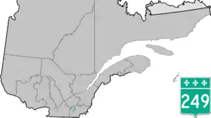
Quebec Route 249
Route 249 is a two-lane north/south highway on the south shore of the Saint Lawrence River in Quebec, Canada. Its northern terminus is in Val-des-Sources at the junction of Route 255, and the southern terminus is at the junction of Route 112 close to Magog.
Route 249 | ||||
|---|---|---|---|---|
 | ||||
| Route information | ||||
| Maintained by Transports Québec | ||||
| Length | 68.8 km[1] (42.8 mi) | |||
| Major junctions | ||||
| South end | ||||
| North end | ||||
| Location | ||||
| Country | Canada | |||
| Province | Quebec | |||
| Major cities | Magog, Sherbrooke, Val-des-Sources | |||
| Highway system | ||||
| ||||

Municipalities along Route 249
- Magog
- Sherbrooke
- Saint-Denis-de-Brompton
- Saint-François-Xavier-de-Brompton, Quebec
- Windsor
- Val-Joli
- Saint-Claude
- Saint-Georges-de-Windsor
- Val-des-Sources
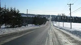 Rhéaume road south of Saint-Denis-de-Brompton.
.jpg.webp) Route 249 shares part of its route with route 222.
Route 249 shares part of its route with route 222..jpg.webp) Principale street in Saint-François-Xavier-de-Brompton.
Principale street in Saint-François-Xavier-de-Brompton..jpg.webp) Route 249 descends in the valley of Saint-François River, near Windsor.
Route 249 descends in the valley of Saint-François River, near Windsor. Bridge over the Saint-François in Windsor.
See also
References
- Ministère des transports, "Distances routières", page 88, Les Publications du Québec, 2005
External links
- Route 249 on Google Maps
- Provincial Route Map (Courtesy of the Quebec Ministry of Transportation) (in French)
This article is issued from Wikipedia. The text is licensed under Creative Commons - Attribution - Sharealike. Additional terms may apply for the media files.