Prague 19
Prague 19, also known as Kbely (German: Gbel), is a municipal district (městská část) in Prague. It is located in the north-eastern part of the city. It is formed by one cadastre, Kbely. As of 2008, there were 6,149 inhabitants living in Prague 19.
Prague 19
Praha 19 | |
|---|---|
Municipal District of Prague Administrative District of Prague | |
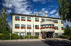 Prague 19 town hall | |
 Flag  Coat of arms | |
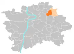 Location of Prague 19 in Prague | |
| Coordinates: 50°8′0″N 14°32′58″E | |
| Country | Czech Republic |
| Region | Prague |
| Government | |
| • Mayor | Pavel Žďárský |
| Area | |
| • Total | 5.99 km2 (2.31 sq mi) |
| Population (2021) | |
| • Total | 7,216 |
| • Density | 1,200/km2 (3,100/sq mi) |
| Time zone | UTC+1 (CET) |
| • Summer (DST) | UTC+2 (CEST) |
| Postal code | 197 00 |
| Website | http://www.praha-kbely.cz |
The administrative district (správní obvod) of the same name consists of municipal districts Prague 19, Satalice and Vinoř.
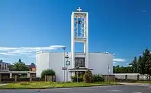
Church of Saint Elisabeth in Kbely
Demographics
| Year | Pop. | ±% |
|---|---|---|
| 1869 | 677 | — |
| 1880 | 898 | +32.6% |
| 1890 | 1,054 | +17.4% |
| 1900 | 1,322 | +25.4% |
| 1910 | 1,518 | +14.8% |
| 1921 | 1,765 | +16.3% |
| 1930 | 5,546 | +214.2% |
| 1950 | 5,884 | +6.1% |
| 1961 | 6,929 | +17.8% |
| 1970 | 6,698 | −3.3% |
| 1980 | 5,688 | −15.1% |
| 1991 | 4,669 | −17.9% |
| 2001 | 4,592 | −1.6% |
| 2011 | 6,768 | +47.4% |
| 2021 | 7,216 | +6.6% |
| Source: Censuses[1][2] | ||
See also
External links
- "Historický lexikon obcí České republiky 1869–2011 – Praha" (in Czech). Czech Statistical Office. 2015-12-21. pp. 7–8.
- "Population Census 2021: Population by sex". Public Database. Czech Statistical Office. 2021-03-27.
This article is issued from Wikipedia. The text is licensed under Creative Commons - Attribution - Sharealike. Additional terms may apply for the media files.