Prague 16
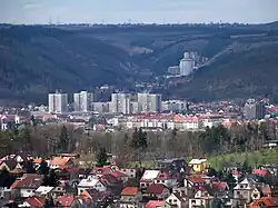
Prague 16 is a municipal district (městská část) of Prague. It has about 8,500 inhabitants. It is located in the south-western part of the city. It is formed by one cadastre, Radotín.
Prague 16
Praha 16 | |
|---|---|
 Radotín | |
 Flag 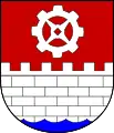 Coat of arms | |
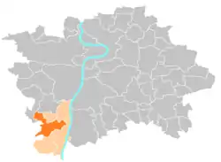 Location of Prague 16 in Prague | |
| Coordinates: 49°59′3″N 14°21′28″E | |
| Country | |
| Region | Prague |
| Government | |
| • Mayor | Karel Hanzlík |
| Area | |
| • Total | 9.31 km2 (3.59 sq mi) |
| Population (2021)[1] | |
| • Total | 8,462 |
| • Density | 910/km2 (2,400/sq mi) |
| Time zone | UTC+1 (CET) |
| • Summer (DST) | UTC+2 (CEST) |
| Postal code | 153 00 |
| Website | www |
The administrative district (správní obvod) of the same name consists of municipal districts Prague 16, Lipence, Lochkov, Velká Chuchle and Zbraslav.
| Year | Pop. | ±% |
|---|---|---|
| 1869 | 494 | — |
| 1880 | 628 | +27.1% |
| 1890 | 944 | +50.3% |
| 1900 | 1,273 | +34.9% |
| 1910 | 1,800 | +41.4% |
| 1921 | 2,276 | +26.4% |
| 1930 | 4,704 | +106.7% |
| 1950 | 5,349 | +13.7% |
| 1961 | 6,152 | +15.0% |
| 1970 | 6,813 | +10.7% |
| 1980 | 6,399 | −6.1% |
| 1991 | 7,053 | +10.2% |
| 2001 | 7,089 | +0.5% |
| 2011 | 8,486 | +19.7% |
| 2021 | 8,462 | −0.3% |
| Source: Censuses[2][3] | ||
References
- "Výsledky Sčítání 2021 – městské části hl. m. Prahy" (in Czech). Czech Statistical Office. Retrieved 2022-10-10.
- "Historický lexikon obcí České republiky 1869–2011 – Praha" (in Czech). Czech Statistical Office. 2015-12-21. pp. 7–8.
- "Population Census 2021: Population by sex". Public Database. Czech Statistical Office. 2021-03-27.
External links
Wikimedia Commons has media related to Prague 16.
This article is issued from Wikipedia. The text is licensed under Creative Commons - Attribution - Sharealike. Additional terms may apply for the media files.