Perkins, Georgia
Perkins (also Perkins Station) is a census-designated place and unincorporated community in Jenkins County, Georgia, United States. As of the 2010 census it had a population of 91.[2]
Perkins, Georgia | |
|---|---|
 Perkins  Perkins | |
| Coordinates: 32°54′35″N 81°57′10″W | |
| Country | United States |
| State | Georgia |
| County | Jenkins |
| Area | |
| • Total | 2.12 sq mi (5.49 km2) |
| • Land | 2.07 sq mi (5.36 km2) |
| • Water | 0.05 sq mi (0.13 km2) |
| Elevation | 239 ft (73 m) |
| Population (2020) | |
| • Total | 93 |
| • Density | 44.95/sq mi (17.35/km2) |
| Time zone | UTC-5 (Eastern (EST)) |
| • Summer (DST) | UTC-4 (EDT) |
| ZIP code | 30822 |
| FIPS code | 13-60312 |
| GNIS feature ID | 332641 |
It lies a short distance east of U.S. Route 25, 7 miles (11 km) north of the city of Millen, the county seat of Jenkins County.[3] Its elevation is 239 feet (73 m).[4][5]
References
- "2020 U.S. Gazetteer Files". United States Census Bureau. Retrieved December 18, 2021.
- "Geographic Identifiers: 2010 Census Summary File 1 (G001): Perkins CDP, Georgia". American Factfinder. U.S. Census Bureau. Archived from the original on February 13, 2020. Retrieved May 7, 2018.
- Rand McNally. The Road Atlas '05. Skokie: Rand McNally, 2005, p. 28.
- U.S. Geological Survey Geographic Names Information System: Perkins, Georgia, Geographic Names Information System, 1979-09-25. Accessed 2007-12-23.
- Zip Code Lookup
- "Census of Population and Housing". Census.gov. Retrieved June 4, 2016.
External links
Wikimedia Commons has media related to Perkins, Georgia.
- Old Buckhead Church historical marker
Municipalities and communities of Jenkins County, Georgia, United States | ||
|---|---|---|
| City | 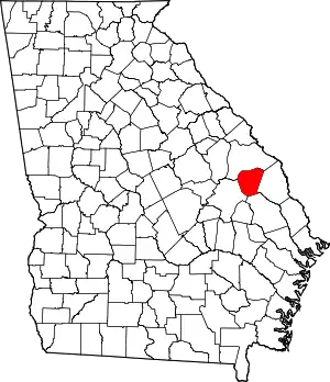 Map of Georgia highlighting Jenkins County | |
| CDP | ||
| Unincorporated communities | ||
This article is issued from Wikipedia. The text is licensed under Creative Commons - Attribution - Sharealike. Additional terms may apply for the media files.