Pawlet (CDP), Vermont
Pawlet is the central village and a census-designated place (CDP) in the town of Pawlet, Rutland County, Vermont, United States. As of the 2020 census, it had a population of 194,[2] out of 1,424 in the entire town.
Pawlet, Vermont | |
|---|---|
 Pawlet  Pawlet | |
| Coordinates: 43°20′47″N 73°10′37″W | |
| Country | United States |
| State | Vermont |
| County | Rutland |
| Town | Pawlet |
| Area | |
| • Total | 2.54 sq mi (6.57 km2) |
| • Land | 2.54 sq mi (6.57 km2) |
| • Water | 0.0 sq mi (0.0 km2) |
| Elevation | 681 ft (208 m) |
| Population | 194 |
| Time zone | UTC-5 (Eastern (EST)) |
| • Summer (DST) | UTC-4 (EDT) |
| ZIP Code | 05761 |
| Area code | 802 |
| FIPS code | 50-54175 |
| GNIS feature ID | 2807153[3] |
The CDP is in southwestern Rutland County, at the geographic center of the town of Pawlet. It sits on the west side of the Taconic Mountains, in the valley of the Mettawee River, a northwest-flowing tributary of Lake Champlain.
Vermont Route 30 passes through the village, leading north 7 miles (11 km) to Wells and southeast 8 miles (13 km) to Dorset. Vermont Route 133 has its southern terminus at Route 30 in Pawlet; it leads north 11 miles (18 km) to Middletown Springs.
References
- "2020 U.S. Gazetteer Files – Vermont". United States Census Bureau. Retrieved October 19, 2021.
- "Pawlet CDP, Vermont: 2020 DEC Redistricting Data (PL 94-171)". U.S. Census Bureau. Retrieved October 19, 2021.
- "Pawlet Census Designated Place". Geographic Names Information System. United States Geological Survey, United States Department of the Interior.
Municipalities and communities of Rutland County, Vermont, United States | ||
|---|---|---|
| City | 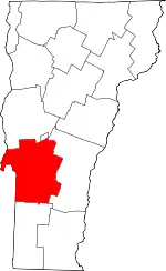 Map of Vermont highlighting Rutland County | |
| Towns | ||
| Village | ||
| CDPs | ||
| Other communities | ||
This article is issued from Wikipedia. The text is licensed under Creative Commons - Attribution - Sharealike. Additional terms may apply for the media files.