Mukims of Brunei
A mukim is the second-level administrative division of Brunei, and the primary subdivision of a district. There are 39 mukims in the country. A mukim is led by a penghulu, since 2015 elected by popular vote. A mukim encompasses a number of villages (kampung or kampong).[1] Mukims are administered by the district office of the district where they are located.
| Administrative divisions of Brunei |
|---|
| First-level |
| Second-level |
| Third-level |
| Outside of hierarchy |
| This article is part of a series on the |
| Politics of Brunei |
|---|
 |
|
|
List of mukims

Mukims of Brunei
| Mukim | District | Population (2016)[2] |
Map |
|---|---|---|---|
| Berakas 'A' | Brunei-Muara[3] | 27,223 | 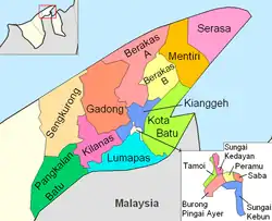
(note that Gadong 'A' and 'B' are shown as one entity) |
| Berakas 'B' | 40,710 | ||
| Burong Pingai Ayer | 1,770 | ||
| Gadong 'A' | 34,049 | ||
| Gadong 'B' | 33,637 | ||
| Kianggeh | 8,228 | ||
| Kilanas | 22,492 | ||
| Kota Batu | 12,935 | ||
| Lumapas | 7,756 | ||
| Mentiri | 30,192 | ||
| Pangkalan Batu | 14,492 | ||
| Peramu | 1,111 | ||
| Saba | 1,000 | ||
| Sengkurong | 31,493 | ||
| Serasa | 16,173 | ||
| Sungai Kebun | 4,750 | ||
| Sungai Kedayan | 230 | ||
| Tamoi | 1,389 | ||
| Bukit Sawat | Belait[4] | 794 | 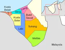 |
| Kuala Balai | 31 | ||
| Kuala Belait | 31,308 | ||
| Labi | 1,216 | ||
| Liang | 14,301 | ||
| Melilas | 29 | ||
| Seria | 21,214 | ||
| Sukang | 169 | ||
| Keriam | Tutong[1] | 9,707 | 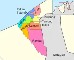 |
| Kiudang | 5,924 | ||
| Lamunin | 4,298 | ||
| Pekan Tutong | 10,551 | ||
| Rambai | 1,404 | ||
| Tanjong Maya | 4,062 | ||
| Telisai | 10,095 | ||
| Ukong | 2,272 | ||
| Amo | Temburong[5] | 2,144 | 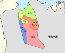 |
| Bangar | 2,449 | ||
| Batu Apoi | 1,635 | ||
| Bokok | 3,433 | ||
| Labu | 590 |
References
- "Tutong District" (PDF). www.information.gov.bn. pp. 7–9. Retrieved 1 March 2018.
- "Table B2 : Total Population, Households and Occupied Living Quarters by Mukims". Retrieved 3 June 2021.
- "Brunei-Muara District" (PDF). www.information.gov.bn. p. 8. Retrieved 1 March 2018.
- "Belait District" (PDF). www.information.gov.bn. pp. 8–9. Retrieved 1 March 2018.
- "Temburong District" (PDF). www.information.gov.bn. p. 8. Retrieved 1 March 2018.
This article is issued from Wikipedia. The text is licensed under Creative Commons - Attribution - Sharealike. Additional terms may apply for the media files.