Monnetier-Mornex
Monnetier-Mornex is a commune in the Haute-Savoie department in the Auvergne-Rhône-Alpes region in south-eastern France.
Monnetier-Mornex | |
|---|---|
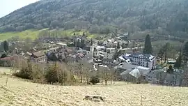 A general view of Monnetier | |
 Coat of arms | |
Location of Monnetier-Mornex | |
 Monnetier-Mornex  Monnetier-Mornex | |
| Coordinates: 46°09′39″N 6°12′28″E | |
| Country | France |
| Region | Auvergne-Rhône-Alpes |
| Department | Haute-Savoie |
| Arrondissement | Saint-Julien-en-Genevois |
| Canton | La Roche-sur-Foron |
| Intercommunality | CC Arve et Salève |
| Government | |
| • Mayor (2021–2026) | Ludovic Wiszniewski[1] |
| Area 1 | 11.4 km2 (4.4 sq mi) |
| Population | 2,332 |
| • Density | 200/km2 (530/sq mi) |
| Time zone | UTC+01:00 (CET) |
| • Summer (DST) | UTC+02:00 (CEST) |
| INSEE/Postal code | 74185 /74560 |
| Elevation | 406–1,268 m (1,332–4,160 ft) |
| Website | www |
| 1 French Land Register data, which excludes lakes, ponds, glaciers > 1 km2 (0.386 sq mi or 247 acres) and river estuaries. | |
This commune is near Geneva and is made up of three villages, Monnetier (Salève and lesser Salève), the village d'Esserts-Saleve and the village of Mornex. Mornex extends to the bottom of Mont Gosse and is beside the confluence of L'Arve river and its tributary the Viaison.
References
- "Répertoire national des élus: les maires" (in French). data.gouv.fr, Plateforme ouverte des données publiques françaises. 4 May 2022.
- "Populations légales 2020". The National Institute of Statistics and Economic Studies. 29 December 2022.
Wikimedia Commons has media related to Monnetier-Mornex.
This article is issued from Wikipedia. The text is licensed under Creative Commons - Attribution - Sharealike. Additional terms may apply for the media files.