Middle Finger (mountain)
The Middle Finger is a mountain in the Five Fingers Group, a group of summits on the divide between Pitt Lake and Coquitlam Lake and north of Widgeon Lake, in British Columbia, Canada.[3][4]
| Middle Finger | |
|---|---|
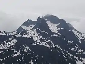 The Middle Finger is the highest peak, just in the clouds. | |
| Highest point | |
| Elevation | 1,890 m (6,200 ft) |
| Prominence | 973 m (3,192 ft) |
| Coordinates | 49°30′58″N 122°42′18″W |
| Geography | |
| Location | British Columbia, Canada |
| District | New Westminster Land District |
| Parent range | Five Fingers Group, Pacific Ranges, Coast Mountains |
| Topo map | NTS 92G10 Pitt River |
| Climbing | |
| First ascent | 1938 L. Harrison; R. Pilkington[1] |
| Easiest route | south side[2] |
The Middle Finger is the highest of the group.
Notes
- Canadian Mountain Encyclopedia Middle Finger
- Fairley p. 250
- Fairley
- Canadian Mountain Encyclopedia Five Fingers Group
References
- Fairley, Bruce (1986). A Guide to Climbing and Hiking in Southwestern British Columbia. Gordon Soules Book Publishers Ltd. ISBN 0-919574-99-8.
- "Middle Finger". Bivouac.com. Retrieved 2007-02-18.
- "Five Fingers Group". Canadian Mountain Encyclopedia. Archived from the original on 2007-09-30. Retrieved 2007-02-18.
This article is issued from Wikipedia. The text is licensed under Creative Commons - Attribution - Sharealike. Additional terms may apply for the media files.