Miandorud County
Miandorud County (Persian: شهرستان میاندورود) is in Mazandaran province, Iran. Its capital is the city of Surak.
Miandorud County
Persian: شهرستان میاندورود | |
|---|---|
County | |
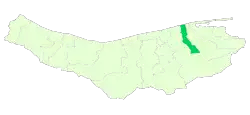 Location of Miandorud County in Mazandaran province | |
 Location of Mazandaran province in Iran | |
| Coordinates: 36°37′N 53°15′E[1] | |
| Country | Iran |
| Province | Mazandaran |
| Capital | Surak |
| Districts | Central, Goharbaran |
| Population (2016)[2] | |
| • Total | 55,053 |
| Time zone | UTC+3:30 (IRST) |
At the 2006 census, the region's population (as Miandorud District of Sari County) was 53,862 in 14,224 households.[3] It was separated from Sari County in 2010.[4] The following census in 2011 counted 55,776 people in 16,670 households.[5] At the 2016 census, the county's population was 55,053 in 18,253 households.[2]
Administrative divisions
The population history and structural changes of Miandorud County's administrative divisions over three consecutive censuses are shown in the following table. The latest census shows two districts, five rural districts, and one city.[2]
| Administrative Divisions | 2006[3] | 2011[5] | 2016[2] |
|---|---|---|---|
| Central District | 40,013 | 40,303 | |
| Kuhdasht Rural District | 20,601 | ||
| Kuhdasht-e Gharbi Rural District | 10,814 | 11,257 | |
| Kuhdasht-e Sharqi Rural District | 10,563 | 10,236 | |
| Miandorud-e Bozorg Rural District | 24,444 | 9,706 | 9,602 |
| Surak (city) | 8,817 | 8,930 | 9,208 |
| Goharbaran District | 15,763 | 14,750 | |
| Goharbaran-e Jonubi Rural District | 6,003 | 5,689 | |
| Goharbaran-e Shomali Rural District | 9,760 | 9,061 | |
| Total | 53,862 | 55,776 | 55,053 |
| 1As a part of Sari County at the 2006 census 2Formerly Miandorud District | |||
Wikimedia Commons has media related to Miandorud County.
References
- OpenStreetMap contributors (26 May 2023). "Miandorud County" (Map). OpenStreetMap. Retrieved 26 May 2023.
- "Census of the Islamic Republic of Iran, 1395 (2016)". AMAR (in Persian). The Statistical Center of Iran. p. 02. Archived from the original (Excel) on 7 October 2021. Retrieved 19 December 2022.
- "Census of the Islamic Republic of Iran, 1385 (2006)". AMAR (in Persian). The Statistical Center of Iran. p. 02. Archived from the original (Excel) on 20 September 2011. Retrieved 25 September 2022.
- "Miandorud County was added to the map of country divisions; with eight changes in the geography of Mazandaran province". DOLAT (in Persian). Ministry of Interior, Board of Ministers. Archived from the original on 31 December 2010. Retrieved 26 May 2023.
- "Census of the Islamic Republic of Iran, 1390 (2011)" (Excel). Iran Data Portal (in Persian). The Statistical Center of Iran. p. 02. Retrieved 19 December 2022.
| Capital | |||||||||||||||||||||||
|---|---|---|---|---|---|---|---|---|---|---|---|---|---|---|---|---|---|---|---|---|---|---|---|
| Districts |
| ||||||||||||||||||||||
This article is issued from Wikipedia. The text is licensed under Creative Commons - Attribution - Sharealike. Additional terms may apply for the media files.