Maradun
Maradun is a Local Government Area in Zamfara State, Nigeria. Its headquarters is in the town of Maradun12°34′00″N 6°14′40″E towards the south of the Area.
Maradun | |
|---|---|
LGA and town | |
 Maradun Location in Nigeria | |
| Coordinates: 12°45′N 6°17′E | |
| Country | |
| State | Zamfara State |
| Area | |
| • Total | 2,728 km2 (1,053 sq mi) |
| Population (2006 census) | |
| • Total | 210,852 |
| Time zone | UTC+1 (WAT) |
| 3-digit postal code prefix | 892 |
| ISO 3166 code | NG.ZA.MD |
It had an area of 2,728 km2 and a population of 210,852 at the 2006 census.
The postal code of the area is 881.[1]
Climate
The yearly temperature in Maradun is 31.88oC, with 86.41 rainy days 23.67% of the time due to the high precipitation levels.[2][3]
Climate change is causing a warmer, colder climate in Maradun, as evidenced by the positive trend of temperature increase.
References
- "Post Offices- with map of LGA". NIPOST. Archived from the original on 2012-11-26. Retrieved 2009-10-20.
- "Maradun, Zamfara, NG Climate Zone, Monthly Averages, Historical Weather Data". tcktcktck.org. Retrieved 2023-09-01.
- "Maradun Climate, Weather By Month, Average Temperature (Nigeria) - Weather Spark". weatherspark.com. Retrieved 2023-09-01.
State capital: Gusau | ||
| Local Government Areas | 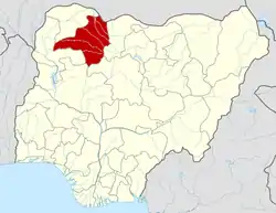 | |
This article is issued from Wikipedia. The text is licensed under Creative Commons - Attribution - Sharealike. Additional terms may apply for the media files.