Liberty Township, Cape Girardeau County, Missouri
Liberty Township is one of ten townships in Cape Girardeau County, Missouri, USA. As of the 2000 census, its population was 483.
Liberty Township | |
|---|---|
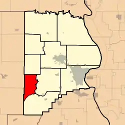 | |
| Coordinates: 37°15′47″N 089°50′20″W | |
| Country | United States |
| State | Missouri |
| County | Cape Girardeau |
| Area | |
| • Total | 25.58 sq mi (66.26 km2) |
| • Land | 25.34 sq mi (65.63 km2) |
| • Water | 0.24 sq mi (0.62 km2) 0.94% |
| Elevation | 407 ft (124 m) |
| Population (2000) | |
| • Total | 483 |
| • Density | 19.1/sq mi (7.4/km2) |
| FIPS code | 29-42014[2] |
| GNIS feature ID | 0766400 |
Liberty Township was established in 1848, and named for the American principle of liberty.[3]
Geography
Liberty Township covers an area of 25.58 square miles (66.3 km2) and contains no incorporated settlements. It contains eight cemeteries: Borneman, Crump, Passover, Proffer, Proffer, Spivey, Stoder and Stroderville.
The streams of Gizzard Creek and Hog Creek run through this township.
References
- "US Board on Geographic Names". United States Geological Survey. October 25, 2007. Retrieved January 31, 2008.
- "U.S. Census website". United States Census Bureau. Retrieved January 31, 2008.
- "Cape Girardeau County Place Names, 1928–1945 (archived)". The State Historical Society of Missouri. Archived from the original on June 24, 2016. Retrieved September 10, 2016.
{{cite web}}: CS1 maint: bot: original URL status unknown (link)
External links
Municipalities and communities of Cape Girardeau County, Missouri, United States | ||
|---|---|---|
| Cities |  Map of Missouri highlighting Cape Girardeau County | |
| Villages | ||
| Townships | ||
| CDPs | ||
| Other communities | ||
| Ghost towns | ||
| Footnotes | ‡This populated place also has portions in an adjacent county or counties | |
This article is issued from Wikipedia. The text is licensed under Creative Commons - Attribution - Sharealike. Additional terms may apply for the media files.