Kurukshetra district
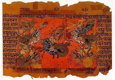
Kurukshetra district is one of the 22 districts of Haryana state in northern India. The town of Kurukshetra, a sacred place for the Hindus, is the administrative headquarters of this district. The district occupies an area of 1530.00 km². The district has a population of 964,655 (2011 census). This district is part of Ambala division. Kurukshetra is also the land of Srimad Bhagawad Gita. Jyotisar is the place in Kurukshetra where Krishna is believed to deliver the sermon of Gita to Arjuna in the Mahabharata.
Kurukshetra district | |
|---|---|
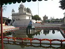
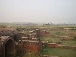
     Statue of Krishna and Arjuna in Kurukshetra, Sthaneshwar Mahadev Temple, Temple in Pehowa, Palace ruins, Sheikh Chilli's Tomb | |
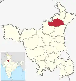
 Location in Haryana | |
| Country | |
| State | Haryana |
| Headquarters | Kurukshetra |
| Tehsils | 1. Thanesar, 2. Shahabad 3. Pehowa, 4.Ladwa |
| Area | |
| • Total | 1,530 km2 (590 sq mi) |
| Population (2011) | |
| • Total | 964,655 |
| • Density | 630/km2 (1,600/sq mi) |
| • Urban | 26.10 |
| Demographics | |
| • Literacy | 76.31 |
| • Sex ratio | 888 |
| Time zone | UTC+05:30 (IST) |
| Lok Sabha constituencies | Kurukshetra (shared with Yamuna Nagar and Kaithal districts) |
| Vidhan Sabha constituencies | 4 |
| Website | http://kurukshetra.gov.in/ |
Origin of name

The district derived its name from the ancient region of Kurukshetra, which literally means the land of the Kurus. It is believed that the Kurukshetra war described in the Puranas and the war was fought here and Shri Krishna preached the Bhagavat Gita to Arjuna on the battlefield before the war.
History
The district was carved out from the erstwhile Karnal district in 1973. Later some parts of this district were transferred to Kaithal and Yamuna Nagar districts at the time of their creation.
Sub-Divisions
The Kurukshetra district is headed by an IAS officer of the rank of Deputy Commissioner (DC) who is the chief executive officer of the district. The district is divided into 4 sub-divisions, each headed by a Sub-Divisional Magistrate (SDM): Shahabad, Thanesar, Ladwa and Pehowa.
Revenue tehsils
The district has 4 revenue tehsils, namely, Thanesar, Pehowa, Shahabad and Ladwa and 2 sub-tehsils - Babain and Ismailabad.
Demographics
| Year | Pop. | ±% p.a. |
|---|---|---|
| 1901 | 175,735 | — |
| 1911 | 158,807 | −1.01% |
| 1921 | 164,560 | +0.36% |
| 1931 | 169,002 | +0.27% |
| 1941 | 197,157 | +1.55% |
| 1951 | 219,455 | +1.08% |
| 1961 | 341,906 | +4.53% |
| 1971 | 465,222 | +3.13% |
| 1981 | 542,423 | +1.55% |
| 1991 | 669,346 | +2.12% |
| 2001 | 825,454 | +2.12% |
| 2011 | 964,655 | +1.57% |
| source:[1] | ||
According to the 2011 census Kurukshetra district has a population of 964,655,[2] roughly equal to the nation of Fiji[3] or the US state of Montana.[4] This gives it a ranking of 452nd in India (out of a total of 640).[2] The district has a population density of 630 inhabitants per square kilometre (1,600/sq mi) .[2] Its population growth rate over the decade 2001-2011 was 16.81%.[2] Kurukshetra has a sex ratio of 889 females for every 1000 males,[2] and a literacy rate of 76.7%. Scheduled Castes make up 22.30% of the population.[2]
Education
Kurukshetra University was established as a unitary residential university at Kurukshetra in 1956. The Regional Engineering College at Kurukshetra was established in 1963, which was later renamed as National Institute of Technology. Kurukshetra has recently got two reputed institutions in the form of National Institute of Design and National Institute of Electronics & Information Technology (NIELIT). Apart from these, the Institute of Hotel Management at Jyotisar is also known.
Transport
Kurukshetra Junction railway station is a junction station at the junction of Delhi–Kalka line and Kurukshetra–Jind branch line.[7] It is located in the Indian state of Haryana. It serves Kurukshetra and Thanesar city.
Ancient sites
.png.webp)
Karn ka Tila, also Raja Karn ka Tila, is a group of partially excavated archeological mounds 5 km southwest of Thanesar and immediately south of Kurukshetra University. There are several mounds, the smaller mound 200 m east of the main mound has
the 4000 years old late phase (1900-1300 BCE) of the Indus-Saraswati Valley Civilisation with a 2-room complex of mud-brick walls.[8]
Partial excavation of 10-meter high main mound found 3 archaeological cultural layers. The oldest Period-I Northern Black Polished Ware (NBPW) has pottery from the 4th century BCE. The 1st-3rd century CE Period-II has Plain Red Ware and Red Polished Ware|Red Polished Ware pottery, 3 clay seals in Brahmi script & terracotta figurines. Habitation at the site was abandoned after period-II, and resettled in the medieval times in the Period-III which has [[lakhori bricks]] and pre-Mughal glazed ware, ruins of late medieval fortification, hauz of lakhauri bricks plastered with lime.[8]
Gita Mahotsav
Kurukshetra is not just the land known as the land of Mahabharta; it is also known for the Philosophy of Life and Karma given to Arjuna by Lord Krishna . For more than 2000 years now, Srimad Bhagawad Gita has emerged as the one scripture which is free from the tags of religions and communities. It is equally reverend all over the world for the message of Selfless Karma which is much relevant in all ages.
Kurukshetra has been celebrating Gita Mahotsav (Gita Jayanti). For long it was known as Kurukshetra Utsav. In 2016, the Haryana Government decided to give it a global fervor and organised annual International Gita Mahotsav at Kurukshetra from 1 December to 11 December. The Gita Jayanti was celebrated on 10 December as per the traditional calendar. In 2016, over 01 Million people visited the events.[9]
References
- Decadal Variation In Population Since 1901
- "District Census 2011". Census2011.co.in. 2011. Retrieved 30 September 2011.
- US Directorate of Intelligence. "Country Comparison:Population". Archived from the original on 13 June 2007. Retrieved 1 October 2011.
Fiji 883,125 July 2011 est.
- "2010 Resident Population Data". U. S. Census Bureau. Archived from the original on 19 October 2013. Retrieved 30 September 2011.
Montana 989,415
- "Table C-01 Population by Religion: Haryana". censusindia.gov.in. Registrar General and Census Commissioner of India.
- "Table C-16 Population by Mother Tongue: Haryana". Census of India. Registrar General and Census Commissioner of India..
- "KKDE/Kurukshetra Junction Railway Station". India Rail Info. Retrieved 29 August 2014.
- Monuments & Sites in Haryana, Archaeological Survey Of India, page 34-35.
- Kurukshetra, Kurukshetra Development Board. "International Gita Mahotsav 2016, Kurukshetra, Haryana, India". internationalgitamahotsav2016.com. Archived from the original on 14 September 2017. Retrieved 17 September 2017.
External links
- Kurukshetra district government website
- Official map of Haryana, showing the cities of Kurukshetra district, hosted on the official website of local government