Jacques Range
The Jacques Range is a mountain range in the Front Ranges of the Canadian Rockies, located south of Highway 16 and Jasper Lake in Jasper National Park, Alberta, Canada.
| Jacques Range | |
|---|---|
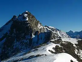 Roche Jacques from the summit of Cinquefoil Mountain | |
| Highest point | |
| Peak | Mount Merlin[1] |
| Elevation | 2,711 m (8,894 ft)[2] |
| Listing | Mountains of Alberta |
| Coordinates | 52°59′07″N 117°50′07″W[3] |
| Dimensions | |
| Area | 121 km2 (47 sq mi)[1] |
| Geography | |
 | |
| Country | Canada |
| Province | Alberta |
| Protected area | Jasper National Park |
| Range coordinates | 53°01′N 117°55′W[4] |
| Parent range | Front Ranges |
| Topo map | NTS 83F4 Miette[4] |
This range includes the following mountains and peaks:[5]
| Name | Elevation (m/ft) | |
|---|---|---|
| Mount Merlin | 2,711 | 8,894 |
| Emir Mountain | 2,616 | 8,583 |
| Roche Jacques | 2,603 | 8,540 |
| Merlin Ridge | 2,362 | 7,749 |
| Cinquefoil Mountain | 2,260 | 7,410 |
See also
References
- "Jacques Range". bivouac.com. Retrieved 2020-04-26.
- "Topographic map of Mount Merlin". opentopomap.org. Retrieved 2023-07-17.
- "Mount Merlin". Geographical Names Data Base. Natural Resources Canada. Retrieved 2023-07-17.
- "Jacques Range". Geographical Names Data Base. Natural Resources Canada. Retrieved 2020-04-26.
- "Jacques Range". cdnrockiesdatabases.ca. Retrieved 2020-04-26.
This article is issued from Wikipedia. The text is licensed under Creative Commons - Attribution - Sharealike. Additional terms may apply for the media files.