Hulín
Hulín (Czech pronunciation: [ˈɦuliːn]; German: Hullein) is a town in Kroměříž District in the Zlín Region of the Czech Republic. It has about 6,500 inhabitants.
Hulín | |
|---|---|
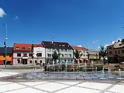
 Town square with the town hall | |
 Flag  Coat of arms | |
 Hulín Location in the Czech Republic | |
| Coordinates: 49°19′0″N 17°27′50″E | |
| Country | |
| Region | Zlín |
| District | Kroměříž |
| First mentioned | 1224 |
| Government | |
| • Mayor | Jaromír Žůrek |
| Area | |
| • Total | 32.12 km2 (12.40 sq mi) |
| Elevation | 191 m (627 ft) |
| Population (2023-01-01)[1] | |
| • Total | 6,524 |
| • Density | 200/km2 (530/sq mi) |
| Time zone | UTC+1 (CET) |
| • Summer (DST) | UTC+2 (CEST) |
| Postal code | 768 24 |
| Website | www |
Administrative parts
Villages of Chrášťany and Záhlinice are administrative parts of Hulín.
Geography
Hulín is located about 5 kilometres (3 mi) east of Kroměříž and 16 km (10 mi) northwest of Zlín. It lies in a flat landscape of the Upper Morava Valley. The Rusava and Mojena streams flow through the town. The Rusava flows into the Morava River, which forms part of the southern border of the territory. There is a system of several ponds south of the town.
History
The first written mention of Hulín is from 1224, when the visit of King Ottokar I was documented. In 1261, the village was donated to the church by King Ottokar II of Bohemia as acknowledgement to bishop Bruno von Schauenburg for his services. Shortly after, Hulín was promoted to a town. At the end of the 13th century, a local small fortress was rebuilt to a bigger castle and the town centre was fortified with walls and a moat.[2]
The local population subsisted mainly on agriculture. The breeding of cattle was significant. In the 1840s, the railway was built and the town slowly began to industrialize.[2]
Demographics
|
|
| ||||||||||||||||||||||||||||||||||||||||||||||||||||||
| Source: Censuses[3][4] | ||||||||||||||||||||||||||||||||||||||||||||||||||||||||
Transport
The town is surrounded by motorways on two sides. The intersection of the D1 and D55 motorways is located in the northern part of the territory.
Sport
SK Spartak Hulín is a football club which played in the Moravian–Silesian Football League (third tier of Czech football system). After relegation in 2019 the club suspended its activities and since the 2020–21 season it plays in lower amateur tiers.
Sights

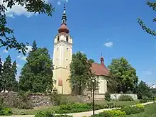
The main landmark of Hulín is the Church of Saint Wenceslaus. It was founded in the early 13th century. The originally Romanesque church was rebuilt into its present form after a fire in 1747.[5]
Notable people
- Zdeněk Nehoda (born 1952), footballer and football agent
- Radek Drulák (born 1962), footballer
- Zdeněk Zlámal (born 1985), footballer; grew up here
References
- "Population of Municipalities – 1 January 2023". Czech Statistical Office. 2023-05-23.
- "Historie" (in Czech). Město Hulín. Retrieved 2021-12-14.
- "Historický lexikon obcí České republiky 1869–2011 – Okres Kroměříž" (in Czech). Czech Statistical Office. 2015-12-21. pp. 1–2.
- "Population Census 2021: Population by sex". Public Database. Czech Statistical Office. 2021-03-27.
- "Kostel sv. Václava a fara" (in Czech). Město Hulín. Retrieved 2023-04-07.
- "Družební setkání ve Zlatých Moravcích", Hulíňan (in Czech), Město Hulín, p. 12, September 2019