Harrisville, New Jersey
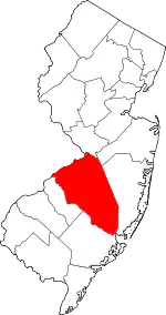
Harrisville (also called Harrisia or McCartyville[1]) is an unincorporated community and ghost town located about 6 miles (9.7 km) northwest of New Gretna within Bass River Township in Burlington County, in the U.S. state of New Jersey, in the New Jersey Pine Barrens.[2][3]
Harrisville, New Jersey | |
|---|---|
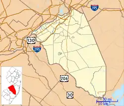 Harrisville Location in Burlington County (Inset: Burlington County in New Jersey)  Harrisville Harrisville (New Jersey)  Harrisville Harrisville (the United States) | |
| Coordinates: 39°39′41″N 74°31′19″W | |
| Country | |
| State | |
| County | Burlington |
| Township | Bass River |
| Established | 1795 |
| Destroyed | 1914[1] |
| Named for | John and Richard Harris[1] |
| Elevation | 16 ft (5 m) |
| Time zone | UTC−05:00 (Eastern (EST)) |
| • Summer (DST) | UTC−04:00 (EDT) |
| GNIS feature ID | 876972[2] |
The first industry in the area of Harrisville comprised two sawmills on the Oswego River (New Jersey), built in about 1750 and 1760 respectively.[4]: 70–71 In 1795, a slitting mill, for cutting iron sheet into strips for nailmaking, was built at the present site of Harrisville by Isaac Potts.[4]: 71 This business was not very successful, and about 1815 it was converted to a paper plant,[1] powered by water brought by a canal from a dam on the Oswego River,[4] a tributary of the Wading River. The town which was built around the factory was originally called McCartyville after the factory owner; when the Harris family bought the factory in 1855, the name was changed to Harrisville. Under the Harris family, Harrisville was a company town, with a grist mill, post office, company store, and free tenant homes for the workers of the paper mill. In 1914, a fire started in Harrisville and destroyed the entire town, leaving only ruins. Only the decayed ruins of this town exist today.[1]
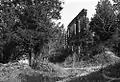 Remains of Harrisville, early 1970s
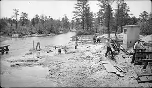 June 1939 WPA construction project on the Oswego River at the CR 679 overpass near Harrisville, just southwest of Harrisville Lake and Harrisville Dam
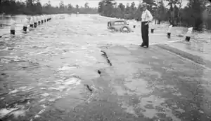 View of the August 20, 1939, Oswego River flood at Harrisville, as seen from where Chatsworth Road/County Route 679 crosses the river. The 1939 flood occurred despite the Harrisville Dam being in place since 1932.
References
- Beck, Henry Charlton (1961) [first published 1936 by E. P. Dutton]. Forgotten Towns of Southern New Jersey (2 ed.). Rutgers University Press. Chapter 23.
- U.S. Geological Survey Geographic Names Information System: Harrisville
- Locality Search, State of New Jersey. Accessed December 28, 2014.
- Pierce, Arthur D. (1957). Iron in the pines: The story of New Jersey's ghost towns and bog iron. Rutgers University Press. p. 67–83. ISBN 9780813505145.
Further reading
- Dellomo, Angelo. Harrisville. Angelo Publishing Company, 1977