Arneys Mount, New Jersey
Arneys Mount is an unincorporated community located within Springfield Township in Burlington County, in the U.S. state of New Jersey.[2] It shares its name with an adjacent hill, Arneys Mount, the highest point in Burlington County.[3] Arney's Mount Friends Meetinghouse and Burial Ground were added to the National Register of Historic Places in 1973.[4]
.jpg.webp)
Arneys Mount high point
Arneys Mount, New Jersey | |
|---|---|
.JPG.webp) Arney's Mount Friends Meetinghouse and Burial Ground, listed on the NRHP | |
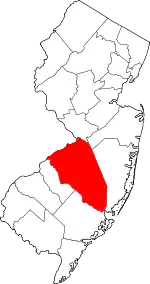
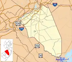 Arneys Mount Location in Burlington County  Arneys Mount Location in New Jersey  Arneys Mount Location in the United States | |
| Coordinates: 40°00′35″N 74°41′48″W | |
| Country | |
| State | |
| County | Burlington |
| Township | Springfield |
| Elevation | 131 ft (40 m) |
| Time zone | UTC−05:00 (Eastern (EST)) |
| • Summer (DST) | UTC−04:00 (EDT) |
| GNIS feature ID | 874380[1] |
References
Wikimedia Commons has media related to Arneys Mount, New Jersey.
- "Arneys Mount". Geographic Names Information System. United States Geological Survey, United States Department of the Interior.
- Locality Search Archived 2016-07-09 at the Wayback Machine, State of New Jersey. Accessed March 13, 2015.
- "New Jersey County High Points". Peakbagger.com. Retrieved June 14, 2015.
- "National Register Information System – (#73001083)". National Register of Historic Places. National Park Service. November 2, 2013.
This article is issued from Wikipedia. The text is licensed under Creative Commons - Attribution - Sharealike. Additional terms may apply for the media files.