Granges-d'Ans
Granges-d'Ans (French pronunciation: [ɡʁɑ̃ʒ dɑ̃s]; Occitan: Granges d'Ans) is a commune in the Dordogne department in Nouvelle-Aquitaine in southwestern France. As part of the Pays d'Ans, it shares a link with the neighbouring communes of Badefols-d'Ans, La Boissière-d'Ans, Chourgnac d’Ans, Sainte-Eulalie-d'Ans and Saint-Pantaly-d'Ans.
Granges-d'Ans | |
|---|---|
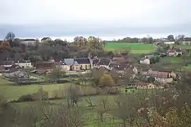
 A general view of Granges-d'Ans | |
Location of Granges-d'Ans | |
 Granges-d'Ans  Granges-d'Ans | |
| Coordinates: 45°12′45″N 1°07′09″E | |
| Country | France |
| Region | Nouvelle-Aquitaine |
| Department | Dordogne |
| Arrondissement | Sarlat-la-Canéda |
| Canton | Haut-Périgord Noir |
| Government | |
| • Mayor (2020–2026) | Jacques Mignot[1] |
| Area 1 | 11.81 km2 (4.56 sq mi) |
| Population | 143 |
| • Density | 12/km2 (31/sq mi) |
| Time zone | UTC+01:00 (CET) |
| • Summer (DST) | UTC+02:00 (CEST) |
| INSEE/Postal code | 24202 /24390 |
| Elevation | 198–338 m (650–1,109 ft) (avg. 244 m or 801 ft) |
| 1 French Land Register data, which excludes lakes, ponds, glaciers > 1 km2 (0.386 sq mi or 247 acres) and river estuaries. | |
Twin town
Since 1999, the Granges d'Ans and its neighbouring communes in Pays d'Ans have been twinned with the Belgian town of Ans.[3] It is reported that in the 14th century, the lord of Hautefort-en-Périgord, an overlord from all over the region, is said to have married one of his daughters to a Lord of Ans in Belgium (Flanders at the time).
Population
| Year | Pop. | ±% |
|---|---|---|
| 1962 | 361 | — |
| 1968 | 314 | −13.0% |
| 1975 | 259 | −17.5% |
| 1982 | 227 | −12.4% |
| 1990 | 209 | −7.9% |
| 1999 | 208 | −0.5% |
| 2008 | 166 | −20.2% |
| 2016 | 155 | −6.6% |
The population of Granges d'Ans has halved since the 1960s and is substantially lower than its historical peak of over 700 in the period 1840–1890.[4] Over 73% of the 2016 population are now over the age of 44 and 53% are female.[5] There is also a secondary population indicated by the housing statistics that show 38% of houses are secondary or vacation homes (55% are primary residences and 7% are vacant).[5]
Historical buildings
River
- Soue
- The tributary of the Auvézère running through the Grotte de Tourtoirac rises in Loqueyssie in Granges d'Ans
Famous people
- Georges Johnston (1773–1844), Landowner of Scottish extraction and Captain in Napoleonic army (aide de camp of General Andre Briche. Father of Georges de Peyrebrune
- Joseph Lachaud de Loqueyssie, French politician married in Granges d'Ans and became owner of Château de Redon
Public transport
The nearest train stations are Gare de La Bachellerie (9 km) and Gare de Thenon (10 km). The TER Nouvelle-Aquitaine services of SNCF connect directly with Bordeaux and Brive.[8]
A bus service from Perigueux operated by Transperigord serves Hautefort.[9]
Adjacent to the La Bachellerie junction of the A89 autoroute is an area for ride sharing ("Aire de covoiturage Chasselines")
The INSEE statistics report that none of the working population utilise public transport for work (75% use car or other vehicle and 25% report no transport or foot).[5]
See also
References
- "Répertoire national des élus: les maires" (in French). data.gouv.fr, Plateforme ouverte des données publiques françaises. 13 September 2022.
- "Populations légales 2020". The National Institute of Statistics and Economic Studies. 29 December 2022.
- RASSAT, Alain. "Un spectacle pour les 20 ans du jumelage à Hautefort". N-System Joomla! Extensions (in French). Retrieved 8 September 2019.
- Des villages de Cassini aux communes d'aujourd'hui: Commune data sheet Granges-d'Ans, EHESS (in French).
- "INSEE Granges d'Ans". Retrieved 8 September 2019.
- "History of Chateau de Redon". Chateau de Redon. Retrieved 21 September 2019.
- "Eglise Saint-Martin". Observatoire du patrimoine religieux. Observatoire du patrimoine religieux. Retrieved 21 September 2019.
- "SNCF Ligne 32 Bordeaux>Brive". TER SNCF nouvelle-aquitaine. Retrieved 8 September 2019.
- "Transperigord". Retrieved 10 September 2019.