Garbolc
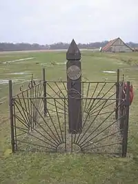
Garbolc is a settlement (village) in Szabolcs-Szatmár-Bereg county, Hungary. Garbolc is located near the easternmost geographical point (the Romanian-Ukrainian-Hungarian triple border point, see the photo; the triple point is 1 km eastward from the leg) of Hungary.
Garbolc | |
|---|---|
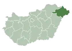
 Garbolc Location of Garbolc in Hungary | |
| Coordinates: 47.94517°N 22.85993°E | |
| Country | Hungary |
| Region | Northern Great Plain |
| County | Szabolcs-Szatmár-Bereg |
| Subregion | Fehérgyarmati |
| Rank | Village |
| Area | |
| • Total | 7.26 km2 (2.80 sq mi) |
| Population (1 January 2008)[2] | |
| • Total | 148 |
| • Density | 20/km2 (53/sq mi) |
| Time zone | UTC+1 (CET) |
| • Summer (DST) | UTC+2 (CEST) |
| Postal code | 4976 |
| Area code | +36 44 |
| KSH code | 04996[1] |
References
- Garbolc at the Hungarian Central Statistical Office (Hungarian).
- Garbolc at the Hungarian Central Statistical Office (Hungarian). 1 January 2008

This article is issued from Wikipedia. The text is licensed under Creative Commons - Attribution - Sharealike. Additional terms may apply for the media files.