Flinders Street, Melbourne
Flinders Street is a street in Melbourne, Victoria, Australia. Running roughly parallel to the Yarra River, Flinders Street forms the southern edge of the Hoddle Grid. It is exactly 1 mi (1.6 km) in length[lower-alpha 1] and one and a half chains (99 ft; 30 m) in width.
Flinders Street | |
|---|---|
 | |
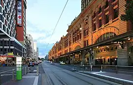
| Flinders Street, facing east from the intersection of Elizabeth Street | |
| General information | |
| Type | Street |
| Length | 2 km (1.2 mi) |
| Route number(s) | |
| Tourist routes | (through Docklands) |
| Major junctions | |
| West end | Docklands, Melbourne |
| East end | East Melbourne |
| Location(s) | |
| LGA(s) | City of Melbourne |
| Suburb(s) | Melbourne |
The street is named after the English explorer, Matthew Flinders, who was erroneously credited with discovering Port Phillip at the time of its naming. It extends eastwards as far as Spring Street and the Treasury Gardens and, originally, westwards to Spencer Street,[lower-alpha 1] but now continues past Batman's Hill to the Melbourne Docklands. As the closest street to the river, Flinders Street served Melbourne's original river port. The Customs House, now the site of Victoria's Immigration Museum, is on Flinders Street.


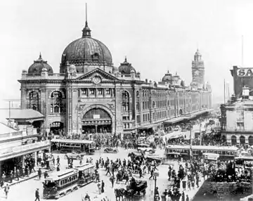
The street is home to Flinders Street station, the central station in Melbourne's suburban rail network. Tram routes 70 and 75, as well as the City Circle route, run along Flinders Street, and the Flinders Street Viaduct runs roughly parallel to the street, linking the city's two major railway stations.
Other landmarks along Flinders Street include Federation Square, St Paul's Cathedral, Young and Jackson Hotel, the Banana Alley Vaults, the old Herald & Weekly Times building, Melbourne Aquarium and Batman Park, which adjoins the Yarra River. The land between the south side of Flinders Street and the railway viaduct between Spencer and King Streets was once home to the Melbourne City Markets,[lower-alpha 2] an ornate building constructed in 1890, covering 23,000 square metres. The market buildings were demolished between 1958 and 1960, after which the site became a public carpark. The site is now home to the three towers of the Northbank Place complex which includes office space, residential apartments, retail outlets and a multi-level carpark. The Melbourne Fish Market was situated on the south side of the railway viaduct, facing Spencer Street, having been displaced from the south-west corner of Flinders and Swanston Streets when the present Flinders Street station was constructed in the early 1900s. The site of the former Fish Market now forms the western end of Batman Park.
King Street Overpass
In the late 1950s, an overpass was built to take King Street over its intersection with Flinders Street, as part of the construction of the King Street Bridge and Kings Way. The overpass extended from Downie Street to just east of Custom House Lane.
Excavation commenced on the foundations of the southern side of the overpass on 6 January 1959 and, by 7 September, the first steel girders were erected.[1] Upon completion of the first stage on 21 November 1959, trams were diverted onto temporary tracks laid by the Melbourne & Metropolitan Tramways Board on that part of the structure. On 23 November 1959, construction on the foundations on the northern side of the overpass commenced and, by 20 February 1960, the remainder of the steelwork on that portion was erected.[1] Following the erection of beams and the concreting of decks and permanent tram tracks, trams were diverted from the temporary tracks during the weekend of 11–13 June 1960. The northern traffic lanes heading eastbound were opened to traffic on 1 July 1960, with southbound lanes open not long afterwards.[1][2]
Many businesses and properties were overshadowed by the overpass which resulted in property values dropping and the closure of hotels, shops and showrooms. Plans to revitalise the area in the early 1960s never eventuated. In May 2002, the state government announced it would be demolished,[3][4] but it was May 2005 before work commenced, with preparations for Melbourne's 2006 Commonwealth Games acting as a catalyst.[5] The project concluded in August.[6]
2017 car attack
On 21 December 2017, a driver ploughed through a crowd on Flinders Street, injuring 19 pedestrians. The perpetrator, Saeed Noori, appeared in court on 23 December, charged with 18 counts of attempted murder and one count of reckless conduct endangering life. According to the Melbourne Police, Noori, a 32-year-old Australian of Afghan descent, had a history of assault, drug use and mental health issues.[7] He was remanded in custody and ordered to undergo a psychiatric assessment.[8]
Notes
- A continuation westward from Spencer Street was constructed in 1890, called Flinders Street Extension.
- Often erroneously identified as the Fish Market
References
- "Country Roads Board Victoria. Forty-Seventh Annual Report: for the year ended 30 June 1960". Country Roads Board. Melbourne: Victorian Government Library Service. 21 November 1960. p. 82.
- "City Overpass Now Open Both Ways". The Age. Melbourne. 12 August 1960. Retrieved 15 September 2023.
- "It's all over for city flyover". The Age. 18 May 2003. Retrieved 15 September 2023.
- "It's All Over For City Flyover". Trolley Wire (290): 18. August 2002.
- "VicRoads Annual Report 2004-05". VicRoads. Melbourne: Victorian Government Library Service. 23 August 2005. p. 71.
- "Flinders Street Overpass Bites The Dust". Government of Victoria. 11 August 2005. Archived from the original on 31 August 2007. Retrieved 15 September 2023.
- "Flinders Street driver was on mental health plan, had no known terror links: Melbourne police". ABC News. 21 December 2017. Retrieved 21 November 2022.
- Mills, Tammy; Bucci, Nino (23 December 2017). "Accused Flinders Street driver Saeed Noori remanded after appearing in court". Sydney Morning Herald. Retrieved 15 September 2023.