Fleury-la-Forêt
Fleury-la-Forêt (French pronunciation: [flœʁi la fɔʁɛ]) is a commune in the Eure department in the Normandy region in northern France.
Fleury-la-Forêt | |
|---|---|
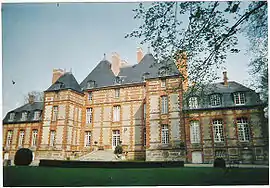 Chateau | |
Location of Fleury-la-Forêt | |
 Fleury-la-Forêt  Fleury-la-Forêt | |
| Coordinates: 49°25′13″N 1°33′21″E | |
| Country | France |
| Region | Normandy |
| Department | Eure |
| Arrondissement | Les Andelys |
| Canton | Romilly-sur-Andelle |
| Government | |
| • Mayor (2020–2026) | Arnaud Godebout[1] |
| Area 1 | 7.85 km2 (3.03 sq mi) |
| Population | 269 |
| • Density | 34/km2 (89/sq mi) |
| Time zone | UTC+01:00 (CET) |
| • Summer (DST) | UTC+02:00 (CEST) |
| INSEE/Postal code | 27245 /27480 |
| Elevation | 119–181 m (390–594 ft) (avg. 167 m or 548 ft) |
| 1 French Land Register data, which excludes lakes, ponds, glaciers > 1 km2 (0.386 sq mi or 247 acres) and river estuaries. | |
Population
| Year | Pop. | ±% |
|---|---|---|
| 1868 | 704 | — |
| 1962 | 202 | −71.3% |
| 1968 | 261 | +29.2% |
| 1975 | 227 | −13.0% |
| 1982 | 215 | −5.3% |
| 1990 | 197 | −8.4% |
| 1999 | 253 | +28.4% |
| 2080 | 266 | +5.1% |
See also
References
- "Répertoire national des élus: les maires" (in French). data.gouv.fr, Plateforme ouverte des données publiques françaises. 13 September 2022.
- "Populations légales 2020". The National Institute of Statistics and Economic Studies. 29 December 2022.
Wikimedia Commons has media related to Fleury-la-Forêt.
This article is issued from Wikipedia. The text is licensed under Creative Commons - Attribution - Sharealike. Additional terms may apply for the media files.