Finestret
Finestret (French pronunciation: [finɛstʁɛt] ⓘ) is a commune in the Pyrénées-Orientales department in southern France.
Finestret | |
|---|---|
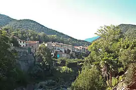 A general view of Finestret | |
Location of Finestret | |
 Finestret  Finestret | |
| Coordinates: 42°37′01″N 2°30′43″E | |
| Country | France |
| Region | Occitania |
| Department | Pyrénées-Orientales |
| Arrondissement | Prades |
| Canton | Le Canigou |
| Government | |
| • Mayor (2020–2026) | Stéphane Gilmant[1] |
| Area 1 | 8.43 km2 (3.25 sq mi) |
| Population | 200 |
| • Density | 24/km2 (61/sq mi) |
| Time zone | UTC+01:00 (CET) |
| • Summer (DST) | UTC+02:00 (CEST) |
| INSEE/Postal code | 66079 /66320 |
| Elevation | 274–1,139 m (899–3,737 ft) (avg. 330 m or 1,080 ft) |
| 1 French Land Register data, which excludes lakes, ponds, glaciers > 1 km2 (0.386 sq mi or 247 acres) and river estuaries. | |
Geography
Finestret is located in the canton of Le Canigou and in the arrondissement of Prades.
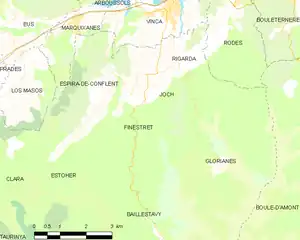
Map of Finestret and its surrounding communes
Population
| Year | Pop. | ±% p.a. |
|---|---|---|
| 1968 | 196 | — |
| 1975 | 154 | −3.39% |
| 1982 | 143 | −1.05% |
| 1990 | 124 | −1.77% |
| 1999 | 135 | +0.95% |
| 2007 | 149 | +1.24% |
| 2012 | 199 | +5.96% |
| 2017 | 176 | −2.43% |
| Source: INSEE[3] | ||
References
- "Répertoire national des élus: les maires". data.gouv.fr, Plateforme ouverte des données publiques françaises (in French). 2 December 2020.
- "Populations légales 2020". The National Institute of Statistics and Economic Studies. 29 December 2022.
- Population en historique depuis 1968, INSEE
Wikimedia Commons has media related to Finestret.
This article is issued from Wikipedia. The text is licensed under Creative Commons - Attribution - Sharealike. Additional terms may apply for the media files.