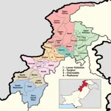
Divisions of Khyber Pakhtunkhwa
The divisions of Khyber Pakhtunkhwa (Urdu: خیبرپختونخوا کےڈویژن ), are the first-order administrative bodies of the Khyber Pakhtunkhwa Province of Pakistan. In total, there are 7 divisions, which are further divided into districts ranging from two to nine per division, depending upon area. Divisions are governed by Commissioners while districts are governed by Deputy Commissioners.
| Divisions of Khyber Pakhtunkhwa | |
|---|---|
 Colors correspond to divisions of Khyber Pakhtunkhwa | |
| Category | First-level administrative division |
| Location | Pakistan |
| Found in | Khyber Pakhtunkhwa |
| Number | 7 (as of 2017[1]) |
| Populations | Greatest: Peshawar — 9,581,281 (2017 census) Least: Bannu — 2,656,801 (2017 census) |
| Areas | Largest: Malakand — 31,162 km2 (12,032 sq mi) Smallest: Mardan —3,175 km2 (1,226 sq mi) |
| Government |
|
| Subdivisions | |
List of divisions
In Pakistan, the division is the administrative unit which is higher in hierarchy than a district, but lower in hierarchy than a province. There are seven divisions in Khyber Pakhtunkhwa, each of which have anywhere between two and nine districts. They are separated by color on the map above, and you can find a list of them below ordered by alphabetical order.
| Division[2] | Districts[2][3][4] | Population (2017)[2] | Total Area[5] | Population Density (2017) | Map |
|---|---|---|---|---|---|
| Bannu Division | 2,656,801 | 9,975 km2 (3,851 sq mi) | 266.35/km2 (689.8/sq mi) | 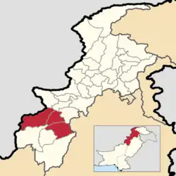 | |
| Dera Ismail Khan Division | 2,803,147 | 18,854 km2 (7,280 sq mi) | 148.68/km2 (385.1/sq mi) | 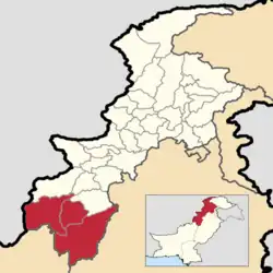 | |
| Hazara Division | 5,325,121 | 17,064 km2 (6,588 sq mi) | 312.07/km2 (808.3/sq mi) | 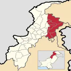 | |
| Kohat Division | 3,211,458 | 12,377 km2 (4,779 sq mi) | 259.47/km2 (672.0/sq mi) | 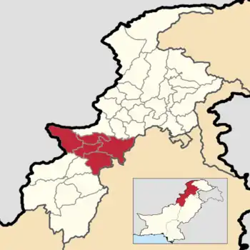 | |
| Malakand Division | 8,608,378 | 31,162 km2 (12,032 sq mi) | 276.25/km2 (715.5/sq mi) | 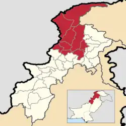 | |
| Mardan Division | 3,997,677 | 3,175 km2 (1,226 sq mi) | 1,259.11/km2 (3,261.1/sq mi) | 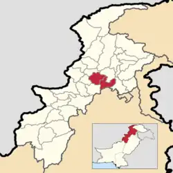 | |
| Peshawar Division | 8,922,465 | 9,134 km2 (3,527 sq mi) | 976.84/km2 (2,530.0/sq mi) | 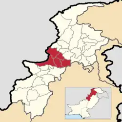 | |
| Abaseen Division |
|
Purposed Division | Purposed Division | Purposed Division | Purposed Division to spelt |
| Dir or Panjkora Division |
|
Purposed Division | Purposed Division | Purposed Division | Purposed Division to spelt
Malakhand Division announced by CM Mehmood Khan on August 13, 2022 |
See also
References
- "Name of All Divisions of KPK Administrative Division Information KPK". www.pakinformation.com. Retrieved 2019-04-05.
- "PROVINCE WISE PROVISIONAL RESULTS OF CENSUS - 2017" (PDF). PAKISTAN TEHSIL WISE FOR WEB CENSUS_2017.pdf. Pakistan Bureau of Statistics. Archived from the original (PDF) on 16 June 2020. Retrieved 16 June 2020.
- "KP govt notifies new divisions following FATA merger". Pakistan Today. 20 July 2018. Archived from the original on 2 July 2020. Retrieved 2 July 2020.
- "KP Districts". kp.gov.pk. Retrieved 2022-05-13.
- "1951 - 1998 POPULATION OF ADMINISTRATIVE UNITS (AS ON 1st MARCH 1998)" (PDF). 1951-98 Population of Administrative Units (As on 1 March 1998).pdf. POPULATION CENSUS ORGANIZATION STATISTICS DIVISION GOVERNMENT OF PAKISTAN. January 2002. Archived (PDF) from the original on 23 August 2020. Retrieved 25 August 2020.
| History | |
|---|---|
| Government | |
| Culture and places |
|
| Geography | |
| Education & Health | |
| Sport | |
| |
Pakistan articles | |||||||||||||||||||
|---|---|---|---|---|---|---|---|---|---|---|---|---|---|---|---|---|---|---|---|
| |||||||||||||||||||
| |||||||||||||||||||
| |||||||||||||||||||
| |||||||||||||||||||
| |||||||||||||||||||
| |||||||||||||||||||