Bonsmoulins
Bonsmoulins (French pronunciation: [bɔ̃mulɛ̃] ⓘ) is a commune in the Orne department in northwestern France.
Bonsmoulins | |
|---|---|
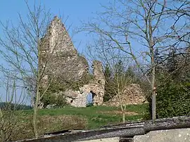 Ruins of the château | |
 Coat of arms | |
Location of Bonsmoulins | |
 Bonsmoulins  Bonsmoulins | |
| Coordinates: 48°39′04″N 0°32′12″E | |
| Country | France |
| Region | Normandy |
| Department | Orne |
| Arrondissement | Mortagne-au-Perche |
| Canton | Tourouvre au Perche |
| Government | |
| • Mayor (2020–2026) | Eric Zo[1] |
| Area 1 | 7.57 km2 (2.92 sq mi) |
| Population | 233 |
| • Density | 31/km2 (80/sq mi) |
| Time zone | UTC+01:00 (CET) |
| • Summer (DST) | UTC+02:00 (CEST) |
| INSEE/Postal code | 61053 /61380 |
| Elevation | 223–291 m (732–955 ft) |
| 1 French Land Register data, which excludes lakes, ponds, glaciers > 1 km2 (0.386 sq mi or 247 acres) and river estuaries. | |
Population
| Year | Pop. | ±% |
|---|---|---|
| 1962 | 211 | — |
| 1968 | 204 | −3.3% |
| 1975 | 176 | −13.7% |
| 1982 | 144 | −18.2% |
| 1990 | 156 | +8.3% |
| 1999 | 213 | +36.5% |
| 2006 | 218 | +2.3% |
| 2009 | 224 | +2.8% |
Heraldry
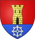
Arms of Bonsmoulins |
The arms of Bonsmoulins are blazoned : Gules, a tower Or open, pierced and masoned sable, issuant from a base azure charged with a millwheel argent. (possibly non-official)
|
See also
References
- "Répertoire national des élus: les maires". data.gouv.fr, Plateforme ouverte des données publiques françaises (in French). 2 December 2020.
- "Populations légales 2020". The National Institute of Statistics and Economic Studies. 29 December 2022.
Wikimedia Commons has media related to Bonsmoulins.
This article is issued from Wikipedia. The text is licensed under Creative Commons - Attribution - Sharealike. Additional terms may apply for the media files.