Arago (lunar crater)
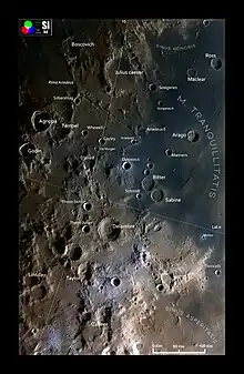
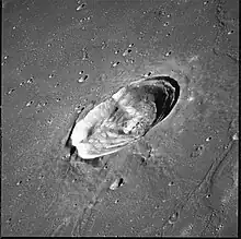
Arago is a lunar impact crater located in the western part of the Mare Tranquillitatis. It was named after French astronomer François Arago in 1935.[1] Its diameter is 26 km.[1] To the southwest lies the crater Manners, and beyond are Dionysius and the Ritter–Sabine crater pair. To the southeast is the large Lamont formation that has been submerged by the mare.
.png.webp) | |
| Coordinates | 6.15°N 21.43°E |
|---|---|
| Diameter | 25.51 km |
| Depth | 1.8 km |
| Colongitude | 358° at sunrise |
| Eponym | François Arago |


The rim of Arago has a bulge in the western wall. There is a central ridge that runs towards the northern wall. The surface of the mare nearby is marked by wrinkle ridges, most notably to the east and southeast. To the north is a large lunar dome designated Arago Alpha (α). A similar-sized lunar dome is located an equal distance to the west, designated Arago Beta (β).
Arago is a crater of Eratosthenian age.[2]
Satellite craters
By convention these features are identified on lunar maps by placing the letter on the side of the crater midpoint that is closest to Arago.
| Arago[1] | Coordinates | Diameter, km |
|---|---|---|
| B | 3.43°N 20.82°E | 6,9 |
| C | 3.89°N 21.48°E | 3,0 |
| D | 6.91°N 22.39°E | 4,0 |
| E | 8.51°N 22.71°E | 6,3 |
References
- "Arago (lunar crater)". Gazetteer of Planetary Nomenclature. USGS Astrogeology Research Program.
- The geologic history of the Moon. USGS Professional Paper 1348. By Don E. Wilhelms, John F. McCauley, and Newell J. Trask. U.S. Government Printing Office, Washington: 1987. Table 12.2.
- Andersson, L. E.; Whitaker, E. A. (1982). NASA Catalogue of Lunar Nomenclature. NASA RP-1097.
- Bussey, B.; Spudis, P. (2004). The Clementine Atlas of the Moon. New York: Cambridge University Press. ISBN 978-0-521-81528-4.
- Cocks, Elijah E.; Cocks, Josiah C. (1995). Who's Who on the Moon: A Biographical Dictionary of Lunar Nomenclature. Tudor Publishers. ISBN 978-0-936389-27-1.
- McDowell, Jonathan (July 15, 2007). "Lunar Nomenclature". Jonathan's Space Report. Retrieved 2007-10-24.
- Menzel, D. H.; Minnaert, M.; Levin, B.; Dollfus, A.; Bell, B. (1971). "Report on Lunar Nomenclature by the Working Group of Commission 17 of the IAU". Space Science Reviews. 12 (2): 136–186. Bibcode:1971SSRv...12..136M. doi:10.1007/BF00171763. S2CID 122125855.
- Moore, Patrick (2001). On the Moon. Sterling Publishing Co. ISBN 978-0-304-35469-6.
- Price, Fred W. (1988). The Moon Observer's Handbook. Cambridge University Press. ISBN 978-0-521-33500-3.
- Rükl, Antonín (1990). Atlas of the Moon. Kalmbach Books. ISBN 978-0-913135-17-4.
- Webb, Rev. T. W. (1962). Celestial Objects for Common Telescopes (6th revised ed.). Dover. ISBN 978-0-486-20917-3.
- Whitaker, Ewen A. (1999). Mapping and Naming the Moon. Cambridge University Press. ISBN 978-0-521-62248-6.
- Wlasuk, Peter T. (2000). Observing the Moon. Springer. ISBN 978-1-85233-193-1.
External links
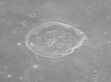
- Lunar Orbiter 2 frame 57, showing Arago C in high resolution
- Wood, Chuck (June 14, 2007). "Something for Everyone". Lunar Photo of the Day. Archived from the original on June 14, 2011.
- Wood, Chuck (December 8, 2009). "Edgy". Lunar Photo of the Day.
