1917 San Salvador earthquake
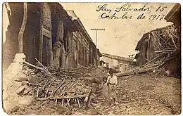
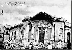
The 1917 San Salvador earthquake occurred on June 7 at 18:55 local time near the Salvadoran capital. The hypocenter of the Mw 6.7 was at a shallow depth of 15 km (9.3 mi), and occurred along a shallow crustal fault near San Salvador.[1] The earthquake caused significant destruction of the city and left approximately 1,050 dead. It was followed by an eruption on San Salvador that killed another 1,100. Only behind the earthquake of 1986, it is the second deadliest in El Salvador's history.[2]
 Ruins of buildings in San Salvador | |
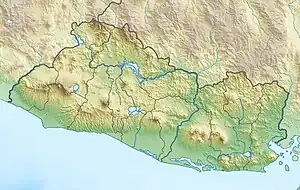
 San Salvador | |
| UTC time | 1917-06-08 00:51:44 |
|---|---|
| ISC event | 913530 |
| USGS-ANSS | ComCat |
| Local date | June 7, 1917 |
| Local time | 18:55 CST |
| Magnitude | 6.7 Mw |
| Depth | 15 km (9.3 mi) |
| Epicenter | 13.802°N 89.361°W [1] |
| Areas affected | El Salvador |
| Max. intensity | VIII (Severe) |
| Casualties | 1,050 killed (earthquake), 1,100 killed (eruption) |
Earthquake
El Salvador lies atop the Chortis Block, near its western margin. It is bounded by the Motagua–Polochic Fault between the North American–Caribbean transform boundary. Along the western margin, at the Middle America Trench, the Cocos Plate subducts beneath it at 70–80 mm (2.8–3.1 in)/year.[3] Subduction produces volcanism along the Central America Volcanic Arc (CAVA) which stretches from Costa Rica to Guatemala. Within the shallow crust of El Salvador, seismicity is associated with the El Salvador Fault Zone (ESFZ), a shear zone. The ESFZ is located within the CAVA, measuring 150 km (93 mi) in length and 20 km (12 mi) across. The ESFZ consists of strike-slip and normal faults which have produced large destructive earthquakes in 1917, 1919, 1965 and 2001. One of these faults, the Guaycume Fault, may have been the source of the earthquake. A slip rate of 9 ± 3 mm (0.35 ± 0.12 in)/yr was suggested along the fault, one of the most dangerous in El Salvador due to its closeness to San Salvador.[4] Another possible source is a fault running beneath the San Salvador volcano that ruptured. The earthquake measured a moment magnitude of 6.7 Mw and surface-wave magnitude of 6.5 Ms . About 30 minutes later, a 6.3 Ms earthquake struck nearby, beneath the San Salvador volcano. An aftershock of 6.0 Ms occurred in 1919.
Impact

The Colombian poet, Porfirio Barba-Jacob, recorded a total of 1,050 fatalities and many injured. In the towns of Armenia and Quezaltepeque, 40 people were killed and over 100 were injured. Damage in San Salvador was severe; described as "80 out of every 100 homes were razed". The business district of San Salvador was incinerated by fires. The large fires killed an estimated 100 people. Residents failed to douse the flames as the city's water systems were wrecked. Out of the 9,000 homes in San Salvador, only 200 remained standing. All government buildings with the exception of the national theater and palace withstood the earthquake. Hospitals, university buildings, schools, and other public structures were razed. The town of Santa Tecla and other nearby communities were levelled.[5][6][7] Surviving buildings eventually toppled during the second major earthquake at 19:30.[8] In addition to damaged buildings, the local coffee plantations were ruined.[9]
San Salvador eruption
The San Salvador volcano erupted about 35 minutes after the 6.3 Ms earthquake. A fissure was observed at 20:11 along the volcanic slope. Smoke bellowed from the fissure and lava was seen. An ash cloud was produced and accompanied by an 8 km (5.0 mi)-long lava flow along the northern slopes. An estimated 800,000 m3 (28,000,000 cu ft) of lava and scoria was ejected. The eruption was the largest since 1671, but was still considered small in size. It may have been triggered by the earthquakes disrupting plumbing within the magma chamber.[10] The lava flows destroyed homes and buried the railway tracks between Quezaltepeque and Sitio del Niño. The site of the eruption and its lava flows are known as Los Chintos.[11] The eruption caused the Boquerón crater lake to evaporate and form a cinder cone in the crater named Boqueroncito—it ejected material up to 200 m (660 ft) high. Approximately 1,100 people were killed, including 500 who perished when they were caught in the lava flows.[12] At least 200 people died from the pyroclastic flows while a further 100 died from lahars. On 10 June, 300 residents were killed by another lava flow.[8] The eruption rated a 3 on the Volcanic explosivity index.[13]
Aftermath
The book El terremoto de San Salvador: narración de un superviviente (The San Salvador Earthquake: A Survivor's Narrative) written by Porfirio Barba-Jacob documents the events of 1917.[14][15]
References
- ISC-GEM Global Instrumental Earthquake Catalogue (1904–2018), Version 9.0, International Seismological Centre
- Huezo, Carlos M. (2004). "Sismos en El Salvador 1900-2001: contexto" (PDF). Servicio Nacional de Estudios Territoriales. Retrieved 17 September 2022.
- Rogers, R. D.; Mann, P.; Emmet, P. A. (2007). "Tectonic terranes of the Chortis block based on integration of regional aeromagnetic and geologic data". In Mann, P. (ed.). Geologic and Tectonic Development of the Caribbean Plate Boundary in Northern Central America. pp. 66–88. doi:10.1130/2007.2428(04). ISBN 9780813724287.
{{cite book}}:|journal=ignored (help) - Alonso-Henar, J.; Benito, B.; Staller, A.; Álvarez-Gómez, J.A.; Martínez-Díaz, J.J.; Canora, C. (2018). "Large-magnitude crustal seismic sources in El Salvador and deterministic hazard scenarios". Engineering Geology. 243: 70–83. doi:10.1016/j.enggeo.2018.06.015. S2CID 134683242.
- Cañas-Dinarte, Carlos. "El Salvador: cronología de una tierra danzarina". El Diario de Hoy. Retrieved 17 September 2022.
- "June 9, 1917 Newspaper Clippings". Department of Earth and Atmospheric Sciences, Saint Louis University. 9 June 1917. Retrieved 17 September 2022.
- National Geophysical Data Center / World Data Service (NGDC/WDS) (1972), Significant Earthquake Database (Data Set), National Geophysical Data Center, NOAA, doi:10.7289/V5TD9V7K
- Lardé y Larín, Jorge (2000). "El Salvador: inundaciones e incendios, erupciones y terremotos". El Salvador: descubrimiento, conquista y colonización. Vol. 5. Consejo Nacional para la Cultura y el Arte. pp. 123–125. ISBN 9992300493.
- Dinarte, Carlos Cañas (7 June 2020). "La erupción del volcán de San Salvador en 1917: la noche trágica de Corpus Christi" [The eruption of the San Salvador volcano in 1917: the tragic night of Corpus Christi]. El Mundo. Retrieved 17 September 2022.
- White, Randall A.; Harlow, David H.; Alvarez, Salvador (1987). "The San Salvador Earthquake of October 10, 1986—Seismological Aspects and Other Recent Local Seismicity". Earthquake Spectra. 3 (3): 419–434. doi:10.1193/1.1585439. S2CID 129240737.
- Barrera, Susana (21 June 2011). "A 94 años de la erupción del volcán de San Salvador" [94 years after the eruption of the San Salvador volcano] (in Spanish). ContraPunto. Archived from the original on 26 June 2011. Retrieved 17 September 2022.
- National Geophysical Data Center / World Data Service (NGDC/WDS) (1972), NCEI/WDS Global Significant Volcanic Eruptions Database. NOAA National Centers for Environmental Information (Data Set), National Geophysical Data Center, NOAA, doi:10.7289/V5JW8BSH
- "San Salvador". Global Volcanism Program. Smithsonian Institution.
- Jacob, Porfirio-Barba (2001). El terremoto de San Salvador: narración de un superviviente. Villegas Editores. p. 238. ISBN 9789589393987.
- "El terremoto de San Salvador" [The San Salvador earthquake]. Noticias de El Salvador. 27 June 2001. Archived from the original on 6 March 2012. Retrieved 17 September 2022.
Further reading
- Roy, Sharat Kumar (30 August 1957). A Restudy of the 1917 Eruption of Volcán Boquerón, El Salvador, Central America. Vol. 10. Chicago Natural History Museum. pp. 363–382.