1833 Shōnai earthquake
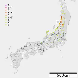
The Shōnai offshore earthquake (Japanese: 庄内沖地震, Hepburn: Shōnai-oki Jishin) occurred at around 14:00 on December 7, 1833. It struck with an epicenter in the Sea of Japan, off the coast of Yamagata Prefecture, Japan. A tsunami was triggered by the estimated MJMA 7.5–7.7 earthquake. One hundred and fifty people were killed and there was severe damage in the prefecture.
 | |
| Local date | December 7, 1833 |
|---|---|
| Local time | 15:00–16:00 JST |
| Magnitude | 7.5–7.7 MJMA |
| Epicenter | 38.9°N 139.25°E[1] |
| Max. intensity | JMA 6+ |
| Tsunami | Yes |
| Casualties | 150 dead |
Tectonic setting
Japan is situated on a convergent boundary between the Pacific, Philippine Sea, Okhotsk and Amurian Plates. Along the island arc's east and southeast coast, subduction of the Pacific and Philippine Sea Plates occur at the Japan Trench and Nankai Trough, respectively. The west coast of Honshu, bordering the Sea of Japan, is a north–south trending convergent boundary.[2] This boundary between the Amurian and Okhotsk Plates is thought to be an incipient subduction zone, consisting of eastward-dipping thrust faults.[3] Convergent tectonics have been occurring in the region since the end of the Pliocene.[4] Earthquakes and tsunamis are produced on thrust faults that form the boundary, with magnitudes in the range of 6.8–7.9. Major earthquakes and tsunamis along this boundary occurred in 1741, 1940, 1964, 1983 and 1993, although the origin of the 1741 tsunami remains open to debate.[5]
Earthquake
The earthquake ruptured the convergent boundary faults of the eastern margin of the Sea of Japan. The rupture zone partially overlaps that of the 1964 earthquake which struck in the same area, although parts of the rupture area extended north. The earthquake had an estimated JMA magnitude (MJMA ) of 7.5–7.7,[6] similar to the 1964 earthquake, while the tsunami magnitude (Mt ) was 8.1. The JMA magnitude was calculated based on the seismic intensities recorded during the earthquake.[7] A seismic gap exist between the rupture areas of the 1833 and 1983 earthquakes, which is capable of generating a magnitude 7.5 earthquake.[3]
Tsunami

Although its seismic magnitude was estimated to be similar to the 1964 earthquake, it generated taller tsunami waves. It is thought to be one of the largest tsunami in the Sea of Japan. The tsunami reached a height of 7–8 m (23–26 ft) at Kamomoya, Yamagata Prefecture, believed to be close to the earthquake source. Large waves were reported along a 30–50 km (19–31 mi) stretch of coastline. In Kisakata (Akita) and Ajigasawa (Aomori), waves 4–5 m (13–16 ft) struck. The tsunami measured 1–3 m (3 ft 3 in – 9 ft 10 in) in Izumozaki, Niigata. A tall wave measuring 5.3 m (17 ft) washed onto Wajima, Ishikawa. Waves exceeding 5 m (16 ft) was reported from Kamo (8 m (26 ft)) to Fuya (7 m (23 ft)).[7] Waves were described as "strong" in Tsuruoka. It traveled 2.5 km (1.6 mi) upstream.[8] At Sakaiminato, Tottori, the tsunami measured 2.3 m (7 ft 7 in).[9]
Impact
A total of 150 fatalities resulted.[6] According to various sources, between 360 and 600 homes were washed away by the tsunami or destroyed in the shaking. Another 1,790 homes sustained partial destruction. In the Shonai region, 158 houses and 322 boats and ships were lost. An estimated 38 residents died in the tsunami. At Sado, 123 homes were destroyed.[10] An additional 47 people died in Wajima,[11] on the Noto Peninsula. A maximum JMA seismic intensity 6 was estimated in an area measuring 80 km (50 mi) in length from Niigata to Yamagata prefectures.[12] Seismic intensity 5 extended 250 km (160 mi) from Niigata to Akita to the Yamagata basin along the Mogami River. Shaking resulted in the partial destruction of Tsuruoka, Oyama, Makisone, Yosida, Okushinden, and Hironoshinden. Generally, damage in the region in proportion to the number of buildings was not great. The greatest damage was reported along the coast. Liquefaction was observed at Matsugasaki, Sado.[13]
References
- "日本付近のおもな被害地震年代表" [Japan Historical Earthquakes Representative]. Seismological Society of Japan. Retrieved 20 June 2022.
- Mulia, Iyan E.; Ishibe, Takeo; Satake, Kenji; Gusman, Aditya Riadi; Murotani, Satoko (3 September 2020). "Regional probabilistic tsunami hazard assessment associated with active faults along the eastern margin of the Sea of Japan". Earth, Planets and Space. 72 (123): 123. Bibcode:2020EP&S...72..123M. doi:10.1186/s40623-020-01256-5. S2CID 221463717. Retrieved 20 June 2022.
- Hurukawa, Nobuo; Harada, Tomoya (2013). "Fault plane of the 1964 Niigata earthquake, Japan, derived from relocation of the mainshock and aftershocks by using the modified joint hypocenter determination and grid search methods". Earth, Planets and Space. 65 (12): 1441–1447. Bibcode:2013EP&S...65.1441H. doi:10.5047/eps.2013.06.007. S2CID 73567424.
- Tamaki, Kensaku; Honza, Eiichi (20 October 1985). "Incipient subduction and deduction along the eastern margin of the Japan Sea". Tectonophysics. 119 (1–4): 381–406. Bibcode:1985Tectp.119..381T. doi:10.1016/0040-1951(85)90047-2. Retrieved 20 June 2022.
- Satake, Kenji (2007). "Volcanic origin of the 1741 Oshima-Oshima tsunami in the Japan Sea" (PDF). Earth Planets Space. 59 (5): 381–390. Bibcode:2007EP&S...59..381S. doi:10.1186/BF03352698. S2CID 55372867.
- Hatori, Tokutaro (1990). "Magnitudes of the 1833 Yamagata-Oki Earthquake in the Japan Sea and its Tsunami". Zisin (Journal of the Seismological Society of Japan). Second Series (in Japanese). 43 (2): 227–232. doi:10.4294/zisin1948.43.2_227.
- Kawakami, Gentaro; Kase, Yoshihiro; Atsushi, Urabe; Takashimizu, Yasuhiro (2017). "Tsunamis and possible tsunamigenic deposits along the eastern margin of the Japan Sea". Journal of the Geological Society of Japan. 123 (10): 857–877. doi:10.5575/geosoc.2017.0054.
- Yata, Toshifumi (2014). "一八三三年庄内沖地震における越後の津波到達点と水死者数". 災害・復興と資料. 4: 27–31.
- Tsuji, Yoshinobu; Moriya, Takumi; Haga, Yayoi; Imai, Kentaro; Matsuoka, Yuya; Imamura, Fumihiko; Iwase, Hiroyuki; Sato, Masami (2017). "天保四年(1833)出羽沖地震津波の隠岐諸島,および島根半島での津波高" [Heights of the Tsunami of the Tenpo Dewa-Oki Earthquake of December 7th, 1833 on the Coasts of Oki Archipelago and Shimane Peninsula] (PDF). Research Report of Tsunami Engineering (in Japanese). 33: 333–356.
- National Geophysical Data Center / World Data Service (NGDC/WDS), Global Historical Tsunami Database (Data Set), NOAA National Centers for Environmental Information
- Hatori, Tokutaro (2012). "新潟県〜石川県沿岸の津波累積エネルギー分布" [Distribution of Cumulative Tsunami Energy along the Niigata to Ishikawa Coasts, the Japan Sea] (PDF). Historical Earthquake (in Japanese). 27.
- Usami, Tatsuo (2003). 最新版 日本被害地震総覧[416]-2001. University of Tokyo Press. ISBN 978-4-13-060742-1.
- National Geophysical Data Center / World Data Service (NGDC/WDS) (1972), Significant Earthquake Database (Data Set), National Geophysical Data Center, NOAA, doi:10.7289/V5TD9V7K