Uşak is a city in the Central Aegean region of Turkey. It has a historic quarter, but the main drawcards are its museum featuring the Lydian treasures and various sights in the surrounding countryside.
Understand

Uşak is at the centre of a region locally known as "Inner Aegean", a transitionary area between the Aegean Region proper and Central Anatolia. While culturally it aligns better with the liberal-leaning Aegean coast, geographically (climatically, in particular) you will certainly start to feel the influence of the continental Anatolian plateau here.
Uşak is an ancient weaving centre. In the past centuries, the export of the local carpets to Europe was such a lucrative business that the Anglified form of its name, Ushak, is considered a proper English noun for the local carpet design. Modern industries include production of foodstuff and bathroom tiles. It also has a university, and there is a student buzz in the centre.
Get in
By plane
Zafer Airport (KZR IATA), about 100 km northeast near Kütahya, is the nearest, but it's often considered a white elephant as it receives so few flights. There is a shuttle bus service into Uşak.
Izmir Adnan Menderes Airport (ADB IATA), 240 km west, serves a much, much wider range of destinations.
By train
The Konya Mavi Treni is a nighttime service between Izmir and Konya via Manisa, Alaşehir, Afyonkarahisar, and Akşehir. It calls in Uşak at the rather inconvenient hour of around 01:45 both directions.
There are also regional trains from Izmir via Manisa, Sart (Sardis), and Alaşehir twice a day, departing in the early morning and afternoon, taking nearly 6 hours and costing 69 TL (Nov 2022).
🌍 Uşak railway station is 1 km south of the main turn-off into the centre on D300/E96.
By bus
By car
Uşak is on D300/E96, the main highway east from Izmir into Anatolia. From Istanbul (470 km) follow O-5 over the Osmangazi Bridge to Bursa to take D200/E90 east to Bozüyük. There, branch off into D650 south. Near Zafer Airport past Kütahya, turn off into D615 to join D300/E96.
Get around
The centre is flat and compact, so is walkable. A fleet of public minibuses run to the suburbs, but you are unlikely to use them.
İsmet Paşa Caddesi is the teeming thoroughfare heading north from the highway overpass; its pedestrianized northern half is particularly lively.
The sides of the main streets in the centre are marked as no parking zones, but the signs are so unheeded throughout the day that you should consider yourself lucky if you can find enough space to stick your car into. Trying the side alleys is a better idea.
See
- 🌍 Atatürk Heykeli (Atatürk ve Kurtuluş Anıtı), İsmet Paşa Cd (in front of the Governor's Office, Valilik). The imposing monument to Atatürk and the 1920–22 Greco-Turkish War or the War of Liberation, the final episodes of which was played out in the vicinity. It marks the beginning of the pedestrianized section of İsmet Paşa Cd.
- 🌍 Old town (at the northern end of İsmet Paşa Cd). The old town is a collection of small squares and cobbled alleys, lined by old houses — those closer to the south are more stately, Neoclassical-influenced mansions mostly converted to businesses (jewellers', restaurants, and hotels) while those to the north are less pretentious Ottoman rowhouses. At the southern entrance of the area, there is a small bazaar (arasta) and a number of historic mosques but perhaps none are monumental enough to specifically seek out.
- 🌍 Atapark (south of the highway). A circular park.

- 🌍 Archaeological Museum (Uşak Müzesi), Doğan Sk 1 (just north of the train station on Orhan Dengiz Blv, the southern extension of İsmet Paşa Cd across the highway; there is a car park just behind it). Tu-Su 09:00-17:00. The museum is somewhat away from the centre, but it should be your first port of call as it's a great introduction to the history and sights in the city and the larger area. The lower floor exhibits finds from the Paleolithic to the Roman era, so you can expect anything from crudely hewn arrowheads to exquisitely carved marble statues. The intermediate floor is of a series of well-curated recreations of trade in Ottoman Uşak while the top floor is dedicated to the Lydians, the pre-Roman civilization of this part of the world. Excellent recreations tell visitors of the Lydian daily life and the chief exhibit is the Lydian treasure, discovered nearby by treasure hunters in the 1960s, smuggled abroad and eventually found their way to New York's Metropolitan Museum of Art before they were repatriated in 1993 after a long legal battle by Turkey. Locally, the treasure (Karun Hazinesi) is attributed to Karun, a character mentioned in the Quran for his enormous wealth and berated for his greed, sometimes associated with Croesus the actual Lydian king, but the information boards in the museum didactically exclaim they are not one and the same. The treasure isn't so much remarkable for the extreme wealth it displays — many of the objects are tiny and aren't even gold — as for the workmanship that went into creating such details. Back on the lower floor on the way out, there is a hall about the Turkish history post-12th century of Uşak. 20 TL.
- See the "Nearby" section below for the historic and natural attractions in the surrounding countryside.
Do
Buy
Eat
- Tarhana is the local delicacy. It's a thick soup traditionally made of a flour and vegetables mixture, fermented, dried and grinded to a powder — a predecessor of instant soups.
- There are lots of eateries along the pedestrian strip.
- 🌍 Meydan Döner, İsmet Paşa Cd 81. Closes by 21:00. Döner wraps. 22-27 TL.
- 🌍 Donas, İsmet Paşa Cd 72/B. Donas is a sticky and hearty döner wrap, common in Anatolian student towns. 43-72 TL.
- 🌍 Çorbacı Dede, Atatürk Bulv 26 (on the highway, about a block west of İsmet Paşa Cd). This is the place for late night soups: lentil, chicken or various offal (but surprisingly no tarhana). Orders come with toasted bread and a tray of greens. 35 TL.
Drink
- 🌍 Chicago, İsmet Paşa Cd 70 (the top floor). Has live music on Saturday nights.
Sleep
- 🌍 Grand Hotel Uzcan, Şehit Mustafa Kemal Akın Sk 3 (off İsmet Paşa Cd), ☏ +90 276 224 60 60. Clean if not spotless rooms with en-suite, TV, air-con, and high street view. A little more of sound insulation would be well received. Has a parking lot down the alley. 550 TL (single), 720 TL (double) including breakfast (buffet but basic).
Connect
Nearby
South
With access to your own transportation, you can have a circular tour of the countryside to the south with some scattered attractions. Combined with a bit of walking, you can also reach a couple of sites by public transport. This tour is best done when the temperatures are above freezing — these are mostly minor backcountry roads over an elevated plateau, and in case of any weather-inflicted problem, you are likely on your own. Also for much of the route, be on the watch for herds of sheep heedlessly running into the road.
The full tour takes about 4 hours, without factoring in any lunch breaks you may have or the return trip to Uşak.
2 km east of the central overpass on D300/E96, branch off south into D595, signposted to Sivaslı. Some distance away from the city, you will arrive at a turn-off with a signpost for the Cılandras. You can follow it and skip Sebaste, but the described route below assumes you are doing the full tour.
At the 30th kilometre out of the city, take the turn-off for Selçikler (there is no signpost for Sebaste here). Proceed across the village and in the fork in front of the Belediye (town council) building, take right. (If you're lost, ask for Roma harabeleri — and good luck with understanding the local Turkish dialect.) As soon as you emerge out of the village, you will notice the ruins of 🌍 Sebaste (34 km from Uşak; free admission) to the left of the road; there is a lay-by to the right where you can park your car.
During the Byzantine period, Sebaste was significant enough to be served by a bishop. But the excavated ruins are scant and somewhat disappointing, being limited to the wall foundations of a couple of churches and a scattering of unidentified marble scraps. (You should have already seen the better preserved artefacts excavated here at the archaeological museum of Uşak.)
Go back to the village to take the other way, now to your right, at the fork in front of the belediye. This will soon bring you to the district centre, Sivaslı, which borrowed its name from ancient Sebaste. At the intersection with the traffic lights, turn right onto D595 south. (There is a signpost for Sebaste at this crossroad, so this is your second chance to visit it if you missed the turn-off for Selçikler earlier on the route. You can also arrive here by taking buses heading south from Uşak, and walk the final 2 km to Sebaste.)
At the 40th kilometre out of Uşak past Pınarbaşı, take the road right towards Karahallı; a signpost for the Cılandras confirms the way. The road takes you across an area with much farming, including some fields providing Turkey's newly emerging lavender production. Once in Karahallı, follow the road to the right for the Cılandras; this climbs up a hill to a junction — you should take the sharp right turn, don't miss the small signpost. At Külköy, take the signposted left turn at a fork. Past the village, the road comes to a T-junction: there is a signpost for the Cılandras but its arrow pointing the correct way is illegible; you should turn right here. The road will soon plunge into a valley, from where you should turn left for the final approach to the Cılandras.
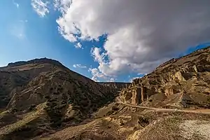
.jpg.webp)
The 🌍 Cılandras Bridge (Cılandras Köprüsü, 75 km from Uşak, free admission) is most likely an aqueduct built by the Phrygians or their successors, the Romans, supplying nearby Pepuza. Pepuza was an ancient city and the headquarters of Montanism, an early Christian movement of the 2nd century, and the adherents of which believed the Messiah would descend on a nearby mountain. The brick bridge is a single arch, a perfect half-circle 17 m high and 24 m long, over the Banaz River coming in from a craggy ravine. Its narrow deck is suitable for passengers to cross, but there is no connecting path on the other side — as of Oct 2022, a plankway connected to another, wooden bridge downstream was in construction towards the dead-end of the bridge so it will be possible to walk around the site without backtracking once it's open. There is an adjacent, 1960s-built small hydropower plant, prettified by wooden covering, but it's an active industrial site, so you can't enter; peek inside to view various machinery doing their thing. The waterfall just upstream from the bridge is artificial; it's the discharge sluice of the power plant. The lush valley is a popular picnic area, so there is a store and other usual amenities, but you may not find them open.
Once you are done here, follow the road signposted to Ulubey Kanyonları. This road initially hairpins through a pine-covered hillside to reach a barren, rocky plateau. Past a couple of villages with adobe and stone buildings traditionally common in the area, you will arrive to a junction; turn right to join a more major road across an open agricultural flatland. At one point, this road descends to the canyon bottom but the scenic viewpoint is 5 km along.
The lookout of 🌍 Ulubey Canyon (Ulubey Kanyonları; free admission) is 108 km away from Uşak on this route — keep to the highway bypass to the right as you are entering Ulubey and turn right at the signpost. It's a little more than 1 km east of the town centre of Ulubey, so it's also quite easily accessible by public transportation. The canyon is purpoted to be the second longest in the world after the Grand Canyon. It might not be truly comparable to its American counterpart, but it's still impressive. There is a glass balcony (10 TL access fee, Oct 2022) you can test your fear of heights, and there is another free viewpoint. There are cafes, restaurants, and souvenir shops within the site, as well as tourist trappy attractions such as an upside-down house. Most, if not all, of the site is wheelchair-friendly.
Back to the Ulubey bypass, turn right. Soon you will arrive at a junction; turn left (signposted to Eşme and Blaundus) here. At another oncoming junction, turn left (this time signposted for Güney and Blaundus) into a minor road, and yet at another junction turn left again into an even lesser road — this is the final part of the approach to Blaundus; a significant length of it is gravel.
🌍 Blaundus (daily 09:00-17:00, free admission, 123 km from Uşak) was an ancient Greek settlement, later conquered by Alexander the Great, whom the locals honoured by minting coins inscribed Blaundeon Makedonon. The archaeological excavations are actively ongoing, and the unearthed ruins are scattered, but you've come for the landscape views and the general vibe just as much as seeing them: this is a lofty site over a ridge with distant views of the mountains and surrounded at all sides except a narrow neck by a canyon — an offshoot of much larger Ulubey Canyon to the northeast. The uncovered pieces include a short section of the city wall across the site's only connection to the "mainland", and a gate through it welcoming you to the site, a temple, sections of a theatre, various bits of Latin and Greek inscriptions, and an interesting structure of mossy slabs at the far end of the ridge that earns the place nickname "Turkey's Stonehenge" — the effect on the approach is similar, but thins out as you come close.
At this point, you have 43 km back to Uşak along the direct road via Ulubey. You can return there, or drive west to Eşme along a scenic road with mountain views (if at one spot disfigured by the tailings of a gold mine — this is the land of Croesus, right?) for Kula on a more westerly point on D300/E96 highway.
West
The 🌍 Çataltepe Bridge (Çatal Köprüsü) is an ancient humpback stone bridge of three arches 50 km west of Uşak or 33 km east of Kula, at the southern side of the highway. Taşyaran Valley (Taşyaran Vadisi) is just to the south, accessed from a road branching off 500 m to the east. It's about 2 km off the highway, past the hamlet of Çaykenarı (free entry). This is a very rocky ravine cut by a stream (its name in Turkish translates "rock-chopper"), which has smoothed some of the rock formations into wave-like structures. A maze of steep stairways leads down to the water level and numerous viewpoints at intermediate levels. A road marked piknik alanları brings you to a wooden observation tower on the highest point of the site.
Go next
- Kula is the first major town to the west. It has a preserved old town and an extensive volcanic area, recognized a global geopark, in its outskirts.
- Izmir and Manisa further to the west are major regional cities. Consider visiting the extensive ruins of the Lydian capital, Sardis, on the way.
- Denizli to the south is the hub for visiting the surreally white landscape of Pamukkale.
- Afyonkarahisar is a traditional city to the east, with a hilltop castle. The highways and railways diverge here northeast to Ankara, the national capital, and southeast to Konya, the capital of the medieval Seljuk Turks and the site of the shrine of Sufi mystic and poet Rumi.
- Çavdarhisar to the north has the impressive ruins of Aizanoi, including the Temple of Zeus. Kütahya, a city with a pretty old town and ancient tilemaking industry, is further on that direction.
| Routes through Uşak |
| Izmir ← Kula ← | W |
→ Afyonkarahisar → Konya |